|
|
|||||||||||||||||
| Point ID: 854 | Downloads | Plots | Site Data | Code: 07EA002 |
|
|
|||||||||||||||||
| Download | |
|---|---|
| Site Descriptor Information | Site Time Series Data |
| Link to all available data | |
| View: | Time Series | All |
| Units: | mm |
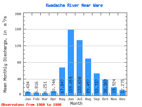
| Statistic | Jan | Feb | Mar | Apr | May | Jun | Jul | Aug | Sep | Oct | Nov | Dec | Annual |
|---|---|---|---|---|---|---|---|---|---|---|---|---|---|
| Mean | 8.43 | 6.82 | 6.25 | 10.75 | 67.85 | 159.06 | 133.64 | 89.50 | 53.74 | 38.37 | 19.92 | 12.28 | 50.63 |
| Standard Deviation | 1.56 | 1.09 | 0.93 | 3.77 | 30.21 | 34.49 | 30.75 | 21.81 | 14.73 | 10.09 | 3.97 | 2.82 | 5.94 |
| Min | 4.00 | 3.06 | 4.26 | 5.49 | 28.70 | 112.00 | 81.10 | 58.20 | 30.20 | 18.60 | 12.10 | 6.80 | 38.08 |
| Max | 11.50 | 9.18 | 8.56 | 22.10 | 134.00 | 235.00 | 200.00 | 145.00 | 95.90 | 63.00 | 27.50 | 17.90 | 60.61 |
| Coefficient of Variation | 0.18 | 0.16 | 0.15 | 0.35 | 0.45 | 0.22 | 0.23 | 0.24 | 0.27 | 0.26 | 0.20 | 0.23 | 0.12 |
 Return to R-Arctic Net Home Page