|
|
|||||||||||||||||
| Point ID: 8092 | Downloads | Plots | Site Data | Code: 1521 |
|
|
|||||||||||||||||
| Download | |
|---|---|
| Site Descriptor Information | Site Time Series Data |
| Link to all available data | |
| View: | Time Series | All |
| Units: | m3/s |
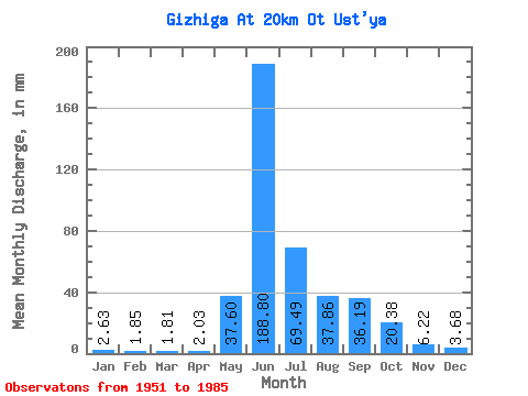
| Statistic | Jan | Feb | Mar | Apr | May | Jun | Jul | Aug | Sep | Oct | Nov | Dec | Annual |
|---|---|---|---|---|---|---|---|---|---|---|---|---|---|
| Mean | 2.63 | 1.86 | 1.81 | 2.03 | 37.59 | 188.80 | 69.48 | 37.86 | 36.19 | 20.38 | 6.22 | 3.68 | 409.40 |
| Standard Deviation | 0.79 | 0.48 | 0.49 | 0.55 | 23.21 | 68.49 | 31.32 | 16.86 | 25.69 | 12.39 | 2.57 | 1.15 | 93.75 |
| Min | 1.21 | 1.11 | 0.97 | 1.09 | 4.23 | 73.33 | 18.47 | 15.91 | 11.21 | 6.48 | 2.16 | 1.79 | 214.21 |
| Max | 5.04 | 3.07 | 2.93 | 3.92 | 106.20 | 354.46 | 151.75 | 81.94 | 110.55 | 53.10 | 14.64 | 5.77 | 612.88 |
| Coefficient of Variation | 0.30 | 0.26 | 0.27 | 0.27 | 0.62 | 0.36 | 0.45 | 0.45 | 0.71 | 0.61 | 0.41 | 0.31 | 0.23 |
 Return to R-Arctic Net Home Page