|
|
|||||||||||||||||
| Point ID: 8092 | Downloads | Plots | Site Data | Code: 1521 |
|
|
|||||||||||||||||
| Download | |
|---|---|
| Site Descriptor Information | Site Time Series Data |
| Link to all available data | |
|
|
| View: | Statistics | Time Series |
| Units: | m3/s |
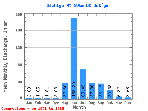
| Statistic | Jan | Feb | Mar | Apr | May | Jun | Jul | Aug | Sep | Oct | Nov | Dec | Annual |
|---|---|---|---|---|---|---|---|---|---|---|---|---|---|
| Mean | 2.63 | 1.86 | 1.81 | 2.03 | 37.59 | 188.80 | 69.48 | 37.86 | 36.19 | 20.38 | 6.22 | 3.68 | 409.40 |
| Standard Deviation | 0.79 | 0.48 | 0.49 | 0.55 | 23.21 | 68.49 | 31.32 | 16.86 | 25.69 | 12.39 | 2.57 | 1.15 | 93.75 |
| Min | 1.21 | 1.11 | 0.97 | 1.09 | 4.23 | 73.33 | 18.47 | 15.91 | 11.21 | 6.48 | 2.16 | 1.79 | 214.21 |
| Max | 5.04 | 3.07 | 2.93 | 3.92 | 106.20 | 354.46 | 151.75 | 81.94 | 110.55 | 53.10 | 14.64 | 5.77 | 612.88 |
| Coefficient of Variation | 0.30 | 0.26 | 0.27 | 0.27 | 0.62 | 0.36 | 0.45 | 0.45 | 0.71 | 0.61 | 0.41 | 0.31 | 0.23 |
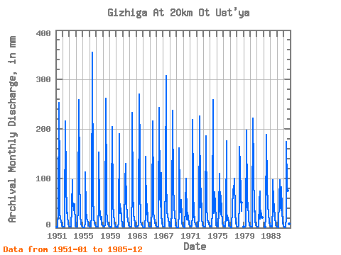
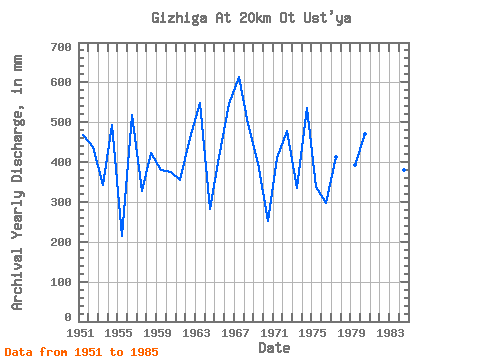
| Year | Jan | Feb | Mar | Apr | May | Jun | Jul | Aug | Sep | Oct | Nov | Dec | Annual | 1951 | 1.51 | 1.15 | 1.05 | 1.25 | 35.25 | 252.55 | 103.00 | 31.36 | 18.10 | 14.40 | 4.43 | 3.46 | 468.24 | 1952 | 2.38 | 1.61 | 1.69 | 2.12 | 20.10 | 216.22 | 97.05 | 30.44 | 31.02 | 22.55 | 7.44 | 3.75 | 437.07 | 1953 | 2.61 | 1.86 | 1.50 | 2.24 | 42.34 | 96.15 | 52.42 | 51.50 | 35.00 | 49.21 | 6.82 | 3.25 | 343.47 | 1954 | 2.56 | 2.11 | 1.98 | 2.26 | 48.30 | 259.20 | 111.47 | 26.09 | 25.25 | 8.81 | 3.43 | 1.94 | 494.21 | 1955 | 1.21 | 1.14 | 1.21 | 1.16 | 11.44 | 112.54 | 34.33 | 19.36 | 14.62 | 9.57 | 3.77 | 3.27 | 214.21 | 1956 | 2.70 | 2.15 | 1.81 | 1.98 | 26.78 | 354.46 | 69.58 | 20.69 | 19.36 | 8.81 | 4.32 | 2.45 | 518.46 | 1957 | 1.85 | 1.93 | 2.03 | 1.79 | 46.01 | 151.97 | 41.89 | 27.92 | 16.88 | 22.75 | 6.98 | 4.55 | 326.68 | 1958 | 3.04 | 2.21 | 2.17 | 2.26 | 6.87 | 261.42 | 79.42 | 36.16 | 14.87 | 7.94 | 3.54 | 2.47 | 424.21 | 1959 | 1.95 | 1.45 | 1.45 | 1.45 | 57.22 | 204.70 | 53.79 | 23.12 | 17.99 | 12.06 | 2.16 | 1.79 | 379.85 | 1960 | 2.03 | 1.24 | 1.28 | 2.07 | 8.49 | 190.30 | 68.21 | 30.90 | 39.43 | 19.66 | 5.72 | 4.05 | 374.55 | 1961 | 2.93 | 2.02 | 2.06 | 2.24 | 93.39 | 130.04 | 39.14 | 37.08 | 23.26 | 16.69 | 4.67 | 2.81 | 355.36 | 1962 | 2.00 | 1.65 | 1.62 | 1.88 | 82.40 | 232.62 | 75.99 | 28.38 | 17.17 | 12.22 | 3.43 | 1.98 | 461.55 | 1963 | 2.12 | 2.08 | 1.93 | 1.84 | 6.09 | 270.28 | 151.75 | 81.94 | 14.11 | 6.96 | 5.58 | 4.07 | 548.64 | 1964 | 2.33 | 1.31 | 1.26 | 1.44 | 26.55 | 144.44 | 27.24 | 49.67 | 15.55 | 6.48 | 3.32 | 2.86 | 282.88 | 1965 | 2.70 | 1.94 | 1.66 | 1.95 | 42.12 | 215.78 | 73.24 | 30.90 | 22.38 | 10.69 | 5.14 | 3.34 | 412.62 | 1966 | 2.61 | 2.15 | 2.20 | 2.07 | 26.09 | 243.69 | 70.73 | 43.49 | 110.55 | 26.32 | 10.17 | 3.66 | 546.13 | 1967 | 2.59 | 2.29 | 1.97 | 2.70 | 106.20 | 307.94 | 103.23 | 35.71 | 21.42 | 18.47 | 5.76 | 4.35 | 612.88 | 1968 | 3.34 | 2.23 | 2.06 | 2.20 | 35.02 | 237.05 | 83.09 | 51.50 | 39.88 | 30.44 | 6.56 | 2.10 | 496.12 | 1969 | 1.43 | 1.11 | 0.97 | 1.15 | 34.10 | 161.06 | 75.99 | 32.27 | 56.05 | 22.00 | 8.82 | 3.27 | 398.58 | 1970 | 2.29 | 1.43 | 1.37 | 1.60 | 45.78 | 99.91 | 18.47 | 17.58 | 30.57 | 21.36 | 6.60 | 5.33 | 252.43 | 1971 | 5.04 | 3.07 | 2.93 | 3.92 | 24.26 | 218.88 | 84.92 | 21.49 | 21.78 | 11.95 | 6.85 | 4.19 | 410.42 | 1972 | 2.81 | 2.05 | 2.61 | 2.15 | 24.03 | 225.97 | 67.29 | 42.80 | 79.75 | 19.78 | 4.87 | 2.68 | 478.64 | 1973 | 2.16 | 1.72 | 2.17 | 2.35 | 43.49 | 185.43 | 41.89 | 18.68 | 11.21 | 13.66 | 6.42 | 4.39 | 334.44 | 1974 | 3.18 | 2.31 | 2.77 | 2.42 | 34.33 | 259.20 | 59.74 | 30.21 | 71.78 | 48.30 | 14.64 | 5.72 | 536.59 | 1975 | 3.04 | 1.92 | 1.88 | 2.46 | 35.94 | 109.66 | 38.00 | 27.92 | 64.91 | 35.71 | 9.33 | 5.58 | 336.58 | 1976 | 3.43 | 2.03 | 1.77 | 2.10 | 22.25 | 175.24 | 36.85 | 15.91 | 21.16 | 9.41 | 3.72 | 3.23 | 298.55 | 1977 | 2.10 | 1.19 | 1.08 | 1.09 | 41.43 | 78.20 | 71.64 | 72.79 | 99.25 | 32.27 | 7.51 | 5.54 | 412.85 | 1978 | 3.75 | 2.63 | 2.52 | 2.97 | 54.25 | 163.94 | 128.64 | 70.50 | 33.23 | 53.10 | 1979 | 1.79 | 1.38 | 1.54 | 1.59 | 4.23 | 197.83 | 62.49 | 41.66 | 51.17 | 16.64 | 6.74 | 4.81 | 393.35 | 1980 | 3.66 | 2.54 | 2.27 | 2.12 | 27.24 | 221.09 | 122.46 | 32.73 | 34.12 | 14.53 | 5.07 | 3.50 | 471.69 | 1981 | 2.38 | 1.35 | 1.71 | 2.09 | 53.79 | 73.33 | 18.72 | 36.62 | 23.93 | 21.45 | 1982 | 2.24 | 20.85 | 188.31 | 86.75 | 48.52 | 47.19 | 28.84 | 10.99 | 5.77 | 1983 | 3.94 | 2.38 | 2.25 | 2.33 | 45.55 | 97.25 | 54.02 | 44.86 | 17.70 | 10.51 | 4.76 | 2.93 | 287.51 | 1984 | 2.56 | 1.57 | 1.44 | 1.78 | 62.26 | 96.59 | 43.26 | 36.85 | 82.86 | 37.54 | 8.13 | 4.94 | 379.30 | 1985 | 3.41 | 2.11 | 1.48 | 1.68 | 21.26 | 174.79 | 85.15 | 77.36 | 23.26 | 12.06 | 7.40 | 3.41 | 412.92 |
|---|
 Return to R-Arctic Net Home Page