|
|
|||||||||||||||||
| Point ID: 8092 | Downloads | Plots | Site Data | Code: 1521 |
|
|
|||||||||||||||||
| Download | |
|---|---|
| Site Descriptor Information | Site Time Series Data |
| Link to all available data | |
| View: | Time Series | All |
| Units: | mm |
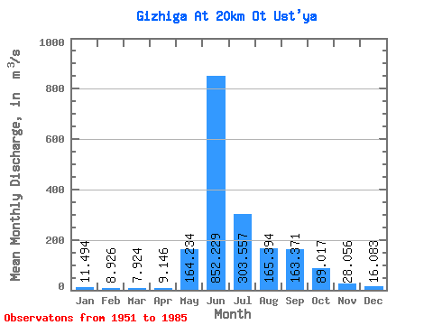
| Statistic | Jan | Feb | Mar | Apr | May | Jun | Jul | Aug | Sep | Oct | Nov | Dec | Annual |
|---|---|---|---|---|---|---|---|---|---|---|---|---|---|
| Mean | 11.49 | 8.93 | 7.92 | 9.15 | 164.23 | 852.23 | 303.56 | 165.39 | 163.37 | 89.02 | 28.06 | 16.08 | 151.78 |
| Standard Deviation | 3.46 | 2.31 | 2.15 | 2.46 | 101.40 | 309.17 | 136.82 | 73.66 | 115.94 | 54.15 | 11.62 | 5.03 | 34.75 |
| Min | 5.27 | 5.33 | 4.22 | 4.91 | 18.50 | 331.00 | 80.70 | 69.50 | 50.60 | 28.30 | 9.75 | 7.84 | 79.41 |
| Max | 22.00 | 14.70 | 12.80 | 17.70 | 464.00 | 1600.00 | 663.00 | 358.00 | 499.00 | 232.00 | 66.10 | 25.20 | 227.21 |
| Coefficient of Variation | 0.30 | 0.26 | 0.27 | 0.27 | 0.62 | 0.36 | 0.45 | 0.45 | 0.71 | 0.61 | 0.41 | 0.31 | 0.23 |
 Return to R-Arctic Net Home Page