|
|
|||||||||||||||||
| Point ID: 7621 | Downloads | Plots | Site Data | Code: 71157 |
|
|
|||||||||||||||||
| Download | |
|---|---|
| Site Descriptor Information | Site Time Series Data |
| Link to all available data | |
| View: | Time Series | All |
| Units: | m3/s |
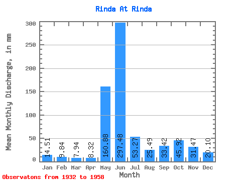
| Statistic | Jan | Feb | Mar | Apr | May | Jun | Jul | Aug | Sep | Oct | Nov | Dec | Annual |
|---|---|---|---|---|---|---|---|---|---|---|---|---|---|
| Mean | 14.51 | 9.92 | 7.94 | 8.32 | 160.85 | 297.48 | 53.26 | 25.48 | 33.42 | 45.92 | 31.47 | 20.10 | 585.14 |
| Standard Deviation | 5.93 | 3.58 | 1.78 | 2.22 | 135.51 | 192.53 | 39.93 | 14.64 | 14.74 | 24.28 | 13.79 | 8.33 | 52.32 |
| Min | 8.50 | 5.13 | 5.38 | 4.66 | 14.48 | 45.49 | 14.15 | 7.68 | 13.12 | 14.40 | 17.32 | 13.94 | 503.62 |
| Max | 25.58 | 14.84 | 10.11 | 10.55 | 524.67 | 785.53 | 205.77 | 66.68 | 61.36 | 90.45 | 54.75 | 32.52 | 629.00 |
| Coefficient of Variation | 0.41 | 0.36 | 0.23 | 0.27 | 0.84 | 0.65 | 0.75 | 0.57 | 0.44 | 0.53 | 0.44 | 0.41 | 0.09 |
 Return to R-Arctic Net Home Page