|
|
|||||||||||||||||
| Point ID: 7621 | Downloads | Plots | Site Data | Code: 71157 |
|
|
|||||||||||||||||
| Download | |
|---|---|
| Site Descriptor Information | Site Time Series Data |
| Link to all available data | |
| View: | Time Series | All |
| Units: | mm |
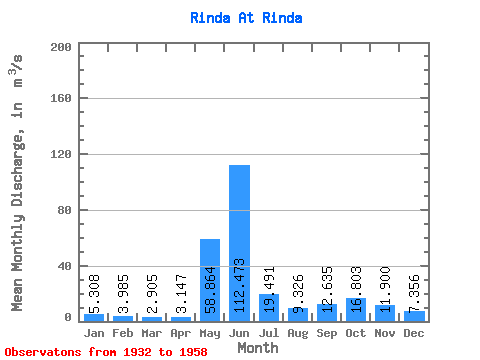
| Statistic | Jan | Feb | Mar | Apr | May | Jun | Jul | Aug | Sep | Oct | Nov | Dec | Annual |
|---|---|---|---|---|---|---|---|---|---|---|---|---|---|
| Mean | 5.31 | 3.98 | 2.91 | 3.15 | 58.86 | 112.47 | 19.49 | 9.33 | 12.63 | 16.80 | 11.90 | 7.36 | 18.17 |
| Standard Deviation | 2.17 | 1.44 | 0.65 | 0.84 | 49.59 | 72.79 | 14.61 | 5.36 | 5.57 | 8.88 | 5.22 | 3.05 | 1.62 |
| Min | 3.11 | 2.06 | 1.97 | 1.76 | 5.30 | 17.20 | 5.18 | 2.81 | 4.96 | 5.27 | 6.55 | 5.10 | 15.64 |
| Max | 9.36 | 5.96 | 3.70 | 3.99 | 192.00 | 297.00 | 75.30 | 24.40 | 23.20 | 33.10 | 20.70 | 11.90 | 19.53 |
| Coefficient of Variation | 0.41 | 0.36 | 0.23 | 0.27 | 0.84 | 0.65 | 0.75 | 0.57 | 0.44 | 0.53 | 0.44 | 0.41 | 0.09 |
 Return to R-Arctic Net Home Page