|
|
|||||||||||||||||
| Point ID: 7621 | Downloads | Plots | Site Data | Code: 71157 |
|
|
|||||||||||||||||
| Download | |
|---|---|
| Site Descriptor Information | Site Time Series Data |
| Link to all available data | |
|
|
| View: | Statistics | Time Series |
| Units: | m3/s |
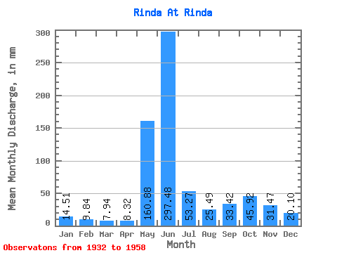
| Statistic | Jan | Feb | Mar | Apr | May | Jun | Jul | Aug | Sep | Oct | Nov | Dec | Annual |
|---|---|---|---|---|---|---|---|---|---|---|---|---|---|
| Mean | 14.51 | 9.92 | 7.94 | 8.32 | 160.85 | 297.48 | 53.26 | 25.48 | 33.42 | 45.92 | 31.47 | 20.10 | 585.14 |
| Standard Deviation | 5.93 | 3.58 | 1.78 | 2.22 | 135.51 | 192.53 | 39.93 | 14.64 | 14.74 | 24.28 | 13.79 | 8.33 | 52.32 |
| Min | 8.50 | 5.13 | 5.38 | 4.66 | 14.48 | 45.49 | 14.15 | 7.68 | 13.12 | 14.40 | 17.32 | 13.94 | 503.62 |
| Max | 25.58 | 14.84 | 10.11 | 10.55 | 524.67 | 785.53 | 205.77 | 66.68 | 61.36 | 90.45 | 54.75 | 32.52 | 629.00 |
| Coefficient of Variation | 0.41 | 0.36 | 0.23 | 0.27 | 0.84 | 0.65 | 0.75 | 0.57 | 0.44 | 0.53 | 0.44 | 0.41 | 0.09 |
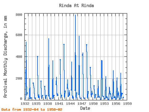
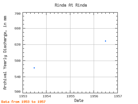
| Year | Jan | Feb | Mar | Apr | May | Jun | Jul | Aug | Sep | Oct | Nov | Dec | Annual | 1932 | 7.14 | 24.18 | 534.27 | 205.77 | 45.63 | 54.48 | 67.22 | 1933 | 14.48 | 195.46 | 33.61 | 15.85 | 13.12 | 20.63 | 1934 | 161.77 | 140.71 | 106.57 | 19.29 | 15.50 | 15.30 | 1935 | 399.38 | 55.47 | 25.03 | 23.96 | 51.37 | 21.29 | 1936 | 180.63 | 45.76 | 14.15 | 12.11 | 32.53 | 41.54 | 1937 | 127.89 | 63.48 | 16.70 | 11.20 | 17.51 | 44.00 | 1938 | 39.62 | 566.01 | 81.43 | 21.75 | 13.99 | 14.40 | 1939 | 16.18 | 362.35 | 39.62 | 15.25 | 30.68 | 42.63 | 1940 | 150.30 | 210.80 | 66.68 | 38.53 | 57.39 | 46.45 | 1941 | 370.29 | 98.65 | 16.70 | 21.16 | 44.00 | 1942 | 510.46 | 41.26 | 16.26 | 41.52 | 85.81 | 1943 | 112.58 | 186.99 | 30.61 | 34.43 | 47.34 | 90.45 | 47.61 | 1944 | 97.28 | 351.77 | 62.30 | 17.22 | 39.14 | 31.15 | 17.32 | 1945 | 93.46 | 785.53 | 44.00 | 7.68 | 30.15 | 66.68 | 1946 | 54.11 | 589.81 | 49.73 | 21.89 | 16.90 | 17.46 | 1947 | 429.03 | 433.76 | 38.80 | 17.93 | 17.16 | 16.29 | 1948 | 524.67 | 380.87 | 25.30 | 13.45 | 39.94 | 79.52 | 1949 | 308.79 | 155.26 | 65.31 | 29.51 | 31.74 | 85.53 | 54.75 | 1950 | 134.17 | 60.83 | 20.00 | 15.79 | 27.51 | 51.10 | 1951 | 27.33 | 183.29 | 71.87 | 28.97 | 36.76 | 26.67 | 1952 | 6.34 | 10.02 | 377.11 | 362.35 | 37.71 | 36.34 | 36.50 | 29.79 | 1953 | 12.08 | 8.71 | 10.11 | 10.55 | 174.62 | 215.29 | 21.37 | 18.55 | 33.06 | 24.21 | 18.62 | 15.14 | 562.12 | 1954 | 8.50 | 5.13 | 5.38 | 4.66 | 121.88 | 110.03 | 55.75 | 57.66 | 61.36 | 42.08 | 19.47 | 13.94 | 503.62 | 1955 | 16.09 | 12.77 | 9.32 | 8.99 | 116.68 | 269.78 | 65.31 | 18.17 | 20.47 | 20.99 | 33.06 | 24.92 | 617.57 | 1956 | 12.52 | 7.32 | 8.34 | 6.67 | 156.03 | 204.45 | 20.69 | 40.72 | 51.05 | 78.70 | 29.62 | 13.99 | 629.00 | 1957 | 12.27 | 10.76 | 8.14 | 10.24 | 256.87 | 45.49 | 16.12 | 66.68 | 57.92 | 59.84 | 41.52 | 32.52 | 613.38 | 1958 | 25.58 | 14.84 |
|---|
 Return to R-Arctic Net Home Page