|
|
|||||||||||||||||
| Point ID: 7486 | Downloads | Plots | Site Data | Code: 70442 |
|
|
|||||||||||||||||
| Download | |
|---|---|
| Site Descriptor Information | Site Time Series Data |
| Link to all available data | |
| View: | Time Series | All |
| Units: | m3/s |
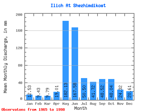
| Statistic | Jan | Feb | Mar | Apr | May | Jun | Jul | Aug | Sep | Oct | Nov | Dec | Annual |
|---|---|---|---|---|---|---|---|---|---|---|---|---|---|
| Mean | 12.53 | 9.51 | 9.79 | 19.01 | 182.10 | 167.57 | 50.50 | 41.71 | 48.52 | 48.03 | 24.32 | 20.61 | 622.75 |
| Standard Deviation | 1.74 | 1.68 | 1.63 | 17.89 | 68.47 | 83.81 | 22.86 | 20.71 | 23.40 | 18.84 | 8.34 | 24.05 | 86.39 |
| Min | 8.73 | 5.08 | 4.09 | 6.38 | 33.84 | 41.88 | 18.87 | 15.20 | 14.56 | 18.09 | 13.05 | 11.50 | 467.27 |
| Max | 15.98 | 12.29 | 12.55 | 84.89 | 294.70 | 314.29 | 97.45 | 88.49 | 109.42 | 115.77 | 58.10 | 153.20 | 818.55 |
| Coefficient of Variation | 0.14 | 0.18 | 0.17 | 0.94 | 0.38 | 0.50 | 0.45 | 0.50 | 0.48 | 0.39 | 0.34 | 1.17 | 0.14 |
 Return to R-Arctic Net Home Page