|
|
|||||||||||||||||
| Point ID: 7486 | Downloads | Plots | Site Data | Code: 70442 |
|
|
|||||||||||||||||
| Download | |
|---|---|
| Site Descriptor Information | Site Time Series Data |
| Link to all available data | |
|
|
| View: | Statistics | Time Series |
| Units: | m3/s |
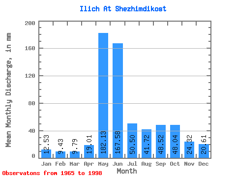
| Statistic | Jan | Feb | Mar | Apr | May | Jun | Jul | Aug | Sep | Oct | Nov | Dec | Annual |
|---|---|---|---|---|---|---|---|---|---|---|---|---|---|
| Mean | 12.53 | 9.51 | 9.79 | 19.01 | 182.10 | 167.57 | 50.50 | 41.71 | 48.52 | 48.03 | 24.32 | 20.61 | 622.75 |
| Standard Deviation | 1.74 | 1.68 | 1.63 | 17.89 | 68.47 | 83.81 | 22.86 | 20.71 | 23.40 | 18.84 | 8.34 | 24.05 | 86.39 |
| Min | 8.73 | 5.08 | 4.09 | 6.38 | 33.84 | 41.88 | 18.87 | 15.20 | 14.56 | 18.09 | 13.05 | 11.50 | 467.27 |
| Max | 15.98 | 12.29 | 12.55 | 84.89 | 294.70 | 314.29 | 97.45 | 88.49 | 109.42 | 115.77 | 58.10 | 153.20 | 818.55 |
| Coefficient of Variation | 0.14 | 0.18 | 0.17 | 0.94 | 0.38 | 0.50 | 0.45 | 0.50 | 0.48 | 0.39 | 0.34 | 1.17 | 0.14 |
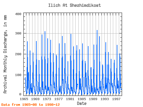
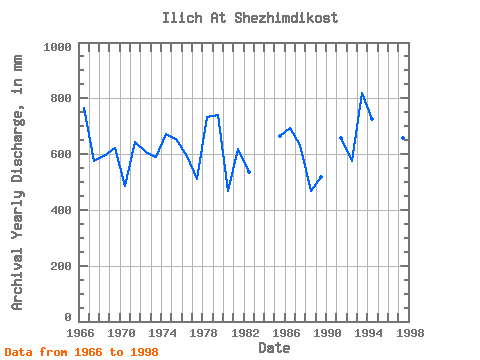
| Year | Jan | Feb | Mar | Apr | May | Jun | Jul | Aug | Sep | Oct | Nov | Dec | Annual | 1965 | 88.49 | 86.40 | 64.32 | 25.28 | 18.48 | 1966 | 15.98 | 11.86 | 10.29 | 11.66 | 268.58 | 109.42 | 31.85 | 44.83 | 103.75 | 115.77 | 31.96 | 15.90 | 767.52 | 1967 | 9.71 | 7.39 | 8.62 | 56.22 | 222.97 | 75.84 | 32.70 | 15.20 | 14.56 | 60.81 | 58.10 | 17.15 | 576.26 | 1968 | 15.16 | 12.29 | 11.23 | 15.43 | 213.23 | 119.98 | 45.22 | 42.49 | 47.16 | 41.32 | 20.98 | 13.80 | 595.37 | 1969 | 10.91 | 7.88 | 8.58 | 12.53 | 33.84 | 261.46 | 88.88 | 77.18 | 64.89 | 23.31 | 21.39 | 11.50 | 623.70 | 1970 | 11.38 | 9.45 | 10.29 | 11.81 | 121.23 | 169.40 | 37.66 | 20.89 | 17.36 | 41.32 | 22.03 | 12.44 | 484.65 | 1971 | 10.56 | 8.45 | 8.42 | 8.00 | 83.03 | 292.78 | 53.79 | 29.16 | 67.16 | 47.17 | 17.85 | 16.10 | 644.33 | 1972 | 11.73 | 8.42 | 9.20 | 10.56 | 66.66 | 308.62 | 42.88 | 29.86 | 36.37 | 47.56 | 19.20 | 13.76 | 607.01 | 1973 | 11.42 | 8.99 | 9.04 | 33.20 | 284.17 | 86.78 | 25.42 | 26.27 | 35.69 | 41.71 | 16.49 | 14.54 | 589.55 | 1974 | 11.30 | 8.70 | 8.46 | 9.62 | 150.47 | 266.75 | 50.67 | 56.13 | 42.63 | 33.72 | 18.37 | 15.20 | 671.82 | 1975 | 11.97 | 9.41 | 9.90 | 26.49 | 210.11 | 117.72 | 66.66 | 37.66 | 66.40 | 56.91 | 24.75 | 20.31 | 655.05 | 1976 | 15.32 | 10.94 | 10.68 | 12.15 | 202.31 | 185.63 | 67.83 | 19.76 | 24.68 | 18.09 | 13.05 | 13.60 | 592.11 | 1977 | 10.53 | 8.24 | 8.26 | 16.11 | 258.83 | 46.41 | 18.87 | 24.52 | 38.48 | 48.34 | 21.81 | 16.18 | 512.10 | 1978 | 12.47 | 10.19 | 9.78 | 11.88 | 81.08 | 285.61 | 90.83 | 59.64 | 77.72 | 48.34 | 25.66 | 19.26 | 733.38 | 1979 | 12.47 | 9.16 | 10.80 | 10.26 | 260.39 | 147.52 | 66.27 | 77.57 | 60.74 | 53.79 | 21.88 | 16.02 | 742.22 | 1980 | 12.59 | 10.19 | 10.33 | 20.03 | 169.96 | 65.27 | 44.05 | 31.69 | 35.31 | 30.33 | 24.37 | 15.87 | 467.27 | 1981 | 12.98 | 11.19 | 10.53 | 9.05 | 90.05 | 296.55 | 41.32 | 26.74 | 22.41 | 41.71 | 34.98 | 18.20 | 617.57 | 1982 | 12.32 | 9.95 | 10.17 | 15.88 | 243.24 | 109.04 | 44.83 | 20.35 | 23.39 | 19.34 | 15.66 | 15.67 | 536.45 | 1983 | 12.63 | 10.19 | 9.78 | 24.52 | 196.07 | 241.09 | 31.18 | 49.12 | 53.58 | 1984 | 12.55 | 13.36 | 228.43 | 131.68 | 34.46 | 30.68 | 81.50 | 33.06 | 30.07 | 29.24 | 1985 | 13.37 | 5.08 | 4.09 | 6.49 | 84.59 | 250.52 | 97.45 | 84.98 | 50.93 | 33.88 | 19.24 | 15.01 | 664.85 | 1986 | 8.73 | 7.00 | 9.51 | 13.58 | 170.74 | 143.75 | 71.33 | 41.71 | 109.42 | 59.64 | 35.54 | 25.26 | 694.25 | 1987 | 15.67 | 6.25 | 6.00 | 6.38 | 244.41 | 92.44 | 95.50 | 67.44 | 35.73 | 39.37 | 17.13 | 13.72 | 634.11 | 1988 | 11.11 | 9.06 | 9.47 | 9.85 | 137.60 | 135.45 | 23.12 | 15.71 | 27.66 | 48.34 | 26.30 | 15.71 | 468.31 | 1989 | 11.38 | 9.20 | 9.39 | 9.24 | 252.60 | 97.72 | 21.67 | 15.87 | 19.54 | 39.76 | 20.11 | 14.07 | 516.89 | 1990 | 11.15 | 8.74 | 10.21 | 22.64 | 179.31 | 314.29 | 33.52 | 22.53 | 30.52 | 20.18 | 14.07 | 1991 | 12.01 | 9.84 | 9.94 | 70.18 | 294.70 | 41.88 | 36.64 | 26.74 | 55.84 | 72.11 | 17.51 | 16.68 | 659.15 | 1992 | 13.33 | 11.12 | 11.30 | 10.22 | 152.81 | 141.86 | 70.17 | 39.37 | 53.20 | 35.86 | 22.03 | 16.61 | 576.00 | 1993 | 14.66 | 12.25 | 11.27 | 12.41 | 166.06 | 256.18 | 34.89 | 34.38 | 42.26 | 61.98 | 21.73 | 153.20 | 818.55 | 1994 | 12.59 | 9.73 | 9.59 | 12.11 | 154.75 | 209.02 | 92.39 | 66.66 | 56.97 | 62.76 | 23.58 | 17.04 | 724.91 | 1995 | 14.03 | 10.97 | 11.27 | 84.89 | 180.87 | 52.82 | 51.84 | 46.00 | 39.24 | 60.81 | 34.98 | 20.04 | 604.82 | 1996 | 14.38 | 11.08 | 11.85 | 11.13 | 147.74 | 170.91 | 47.95 | 47.95 | 46.41 | 48.73 | 28.03 | 16.68 | 601.46 | 1997 | 13.49 | 9.73 | 11.19 | 19.02 | 250.65 | 133.56 | 36.25 | 42.88 | 36.41 | 73.28 | 21.81 | 15.63 | 659.80 | 1998 | 13.68 | 11.40 | 11.07 | 10.41 | 207.77 | 172.04 | 38.28 | 57.69 | 45.27 | 33.68 | 30.37 | 13.25 | 642.88 |
|---|
 Return to R-Arctic Net Home Page