|
|
|||||||||||||||||
| Point ID: 7486 | Downloads | Plots | Site Data | Code: 70442 |
|
|
|||||||||||||||||
| Download | |
|---|---|
| Site Descriptor Information | Site Time Series Data |
| Link to all available data | |
| View: | Time Series | All |
| Units: | mm |
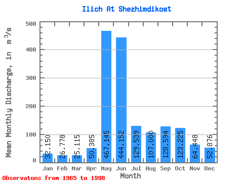
| Statistic | Jan | Feb | Mar | Apr | May | Jun | Jul | Aug | Sep | Oct | Nov | Dec | Annual |
|---|---|---|---|---|---|---|---|---|---|---|---|---|---|
| Mean | 32.15 | 26.78 | 25.11 | 50.38 | 467.14 | 444.15 | 129.54 | 107.00 | 128.59 | 123.22 | 64.45 | 52.88 | 135.56 |
| Standard Deviation | 4.47 | 4.74 | 4.17 | 47.41 | 175.66 | 222.14 | 58.65 | 53.14 | 62.03 | 48.33 | 22.10 | 61.71 | 18.81 |
| Min | 22.40 | 14.30 | 10.50 | 16.90 | 86.80 | 111.00 | 48.40 | 39.00 | 38.60 | 46.40 | 34.60 | 29.50 | 101.72 |
| Max | 41.00 | 34.60 | 32.20 | 225.00 | 756.00 | 833.00 | 250.00 | 227.00 | 290.00 | 297.00 | 154.00 | 393.00 | 178.18 |
| Coefficient of Variation | 0.14 | 0.18 | 0.17 | 0.94 | 0.38 | 0.50 | 0.45 | 0.50 | 0.48 | 0.39 | 0.34 | 1.17 | 0.14 |
 Return to R-Arctic Net Home Page