|
|
|||||||||||||||||
| Point ID: 7480 | Downloads | Plots | Site Data | Code: 70408 |
|
|
|||||||||||||||||
| Download | |
|---|---|
| Site Descriptor Information | Site Time Series Data |
| Link to all available data | |
| View: | Time Series | All |
| Units: | m3/s |
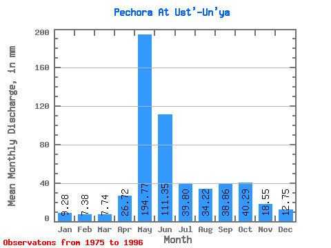
| Statistic | Jan | Feb | Mar | Apr | May | Jun | Jul | Aug | Sep | Oct | Nov | Dec | Annual |
|---|---|---|---|---|---|---|---|---|---|---|---|---|---|
| Mean | 9.28 | 7.44 | 7.74 | 26.72 | 194.74 | 111.35 | 39.80 | 34.21 | 38.86 | 40.28 | 18.55 | 12.75 | 536.42 |
| Standard Deviation | 2.19 | 1.73 | 1.67 | 32.76 | 56.97 | 64.52 | 20.30 | 18.44 | 17.19 | 16.83 | 7.48 | 2.53 | 88.72 |
| Min | 6.23 | 4.75 | 5.41 | 6.08 | 107.00 | 28.26 | 14.09 | 12.88 | 11.12 | 11.12 | 7.55 | 9.07 | 395.69 |
| Max | 15.84 | 12.56 | 12.33 | 121.70 | 301.05 | 252.18 | 96.72 | 74.36 | 68.46 | 65.29 | 38.15 | 17.35 | 737.05 |
| Coefficient of Variation | 0.24 | 0.23 | 0.21 | 1.23 | 0.29 | 0.58 | 0.51 | 0.54 | 0.44 | 0.42 | 0.40 | 0.20 | 0.17 |
 Return to R-Arctic Net Home Page