|
|
|||||||||||||||||
| Point ID: 7480 | Downloads | Plots | Site Data | Code: 70408 |
|
|
|||||||||||||||||
| Download | |
|---|---|
| Site Descriptor Information | Site Time Series Data |
| Link to all available data | |
| View: | Time Series | All |
| Units: | mm |
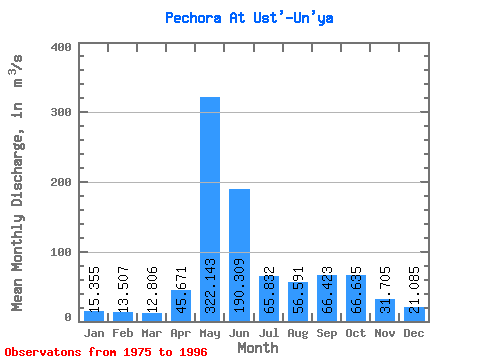
| Statistic | Jan | Feb | Mar | Apr | May | Jun | Jul | Aug | Sep | Oct | Nov | Dec | Annual |
|---|---|---|---|---|---|---|---|---|---|---|---|---|---|
| Mean | 15.36 | 13.51 | 12.81 | 45.67 | 322.14 | 190.31 | 65.83 | 56.59 | 66.42 | 66.64 | 31.70 | 21.09 | 75.30 |
| Standard Deviation | 3.62 | 3.15 | 2.76 | 55.99 | 94.25 | 110.27 | 33.58 | 30.50 | 29.37 | 27.84 | 12.79 | 4.19 | 12.45 |
| Min | 10.30 | 8.63 | 8.95 | 10.40 | 177.00 | 48.30 | 23.30 | 21.30 | 19.00 | 18.40 | 12.90 | 15.00 | 55.54 |
| Max | 26.20 | 22.80 | 20.40 | 208.00 | 498.00 | 431.00 | 160.00 | 123.00 | 117.00 | 108.00 | 65.20 | 28.70 | 103.46 |
| Coefficient of Variation | 0.24 | 0.23 | 0.21 | 1.23 | 0.29 | 0.58 | 0.51 | 0.54 | 0.44 | 0.42 | 0.40 | 0.20 | 0.17 |
 Return to R-Arctic Net Home Page