|
|
|||||||||||||||||
| Point ID: 7480 | Downloads | Plots | Site Data | Code: 70408 |
|
|
|||||||||||||||||
| Download | |
|---|---|
| Site Descriptor Information | Site Time Series Data |
| Link to all available data | |
|
|
| View: | Statistics | Time Series |
| Units: | m3/s |
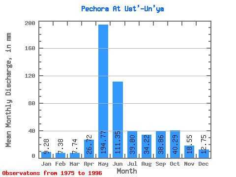
| Statistic | Jan | Feb | Mar | Apr | May | Jun | Jul | Aug | Sep | Oct | Nov | Dec | Annual |
|---|---|---|---|---|---|---|---|---|---|---|---|---|---|
| Mean | 9.28 | 7.44 | 7.74 | 26.72 | 194.74 | 111.35 | 39.80 | 34.21 | 38.86 | 40.28 | 18.55 | 12.75 | 536.42 |
| Standard Deviation | 2.19 | 1.73 | 1.67 | 32.76 | 56.97 | 64.52 | 20.30 | 18.44 | 17.19 | 16.83 | 7.48 | 2.53 | 88.72 |
| Min | 6.23 | 4.75 | 5.41 | 6.08 | 107.00 | 28.26 | 14.09 | 12.88 | 11.12 | 11.12 | 7.55 | 9.07 | 395.69 |
| Max | 15.84 | 12.56 | 12.33 | 121.70 | 301.05 | 252.18 | 96.72 | 74.36 | 68.46 | 65.29 | 38.15 | 17.35 | 737.05 |
| Coefficient of Variation | 0.24 | 0.23 | 0.21 | 1.23 | 0.29 | 0.58 | 0.51 | 0.54 | 0.44 | 0.42 | 0.40 | 0.20 | 0.17 |
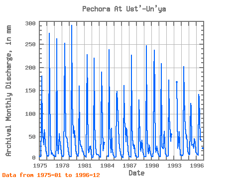
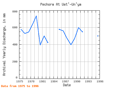
| Year | Jan | Feb | Mar | Apr | May | Jun | Jul | Aug | Sep | Oct | Nov | Dec | Annual | 1975 | 8.58 | 7.00 | 7.13 | 72.55 | 187.40 | 63.19 | 44.43 | 33.49 | 64.95 | 55.49 | 20.19 | 15.78 | 577.65 | 1976 | 11.67 | 7.88 | 8.22 | 11.47 | 282.31 | 121.70 | 28.59 | 12.88 | 16.09 | 13.54 | 9.60 | 10.04 | 530.33 | 1977 | 8.46 | 7.21 | 7.50 | 31.71 | 270.82 | 37.09 | 14.09 | 31.13 | 56.23 | 44.67 | 27.32 | 15.84 | 547.85 | 1978 | 9.55 | 7.11 | 7.19 | 12.70 | 114.25 | 252.18 | 52.53 | 50.30 | 47.86 | 45.28 | 20.95 | 12.94 | 633.04 | 1979 | 8.40 | 7.49 | 7.68 | 6.90 | 301.05 | 127.55 | 59.73 | 74.36 | 48.62 | 65.29 | 21.47 | 14.45 | 737.05 | 1980 | 11.67 | 8.37 | 8.46 | 19.07 | 164.43 | 46.05 | 30.41 | 30.71 | 29.37 | 19.53 | 19.02 | 11.24 | 395.69 | 1981 | 10.10 | 8.37 | 7.38 | 6.08 | 107.00 | 227.02 | 26.30 | 16.32 | 17.96 | 29.74 | 29.49 | 14.57 | 501.30 | 1982 | 6.23 | 4.75 | 6.47 | 14.28 | 227.30 | 75.48 | 32.89 | 16.44 | 11.12 | 11.12 | 11.47 | 10.64 | 424.62 | 1983 | 8.52 | 6.22 | 5.85 | 60.27 | 196.47 | 129.31 | 20.92 | 28.47 | 37.33 | 1984 | 8.71 | 8.72 | 246.04 | 77.82 | 33.79 | 16.62 | 67.87 | 25.69 | 12.29 | 9.79 | 1985 | 7.62 | 5.84 | 6.29 | 6.79 | 143.87 | 147.45 | 96.72 | 73.75 | 39.09 | 29.92 | 13.98 | 9.37 | 577.59 | 1986 | 8.28 | 6.28 | 5.41 | 18.31 | 165.64 | 83.08 | 69.52 | 40.74 | 68.46 | 63.47 | 21.36 | 14.21 | 561.47 | 1987 | 8.28 | 6.50 | 6.83 | 6.32 | 233.34 | 72.55 | 32.70 | 34.82 | 24.69 | 32.77 | 7.55 | 9.07 | 471.14 | 1988 | 7.19 | 5.95 | 6.47 | 7.08 | 134.20 | 87.77 | 23.58 | 19.53 | 32.18 | 43.83 | 18.08 | 12.45 | 396.46 | 1989 | 7.98 | 6.11 | 6.83 | 7.02 | 255.10 | 78.40 | 20.67 | 14.03 | 18.55 | 32.58 | 15.27 | 10.22 | 468.77 | 1990 | 7.98 | 6.78 | 7.38 | 19.72 | 194.65 | 237.55 | 28.05 | 17.23 | 22.35 | 30.41 | 16.09 | 11.73 | 599.44 | 1991 | 9.13 | 7.88 | 7.74 | 97.13 | 215.21 | 28.26 | 26.42 | 25.03 | 47.22 | 63.47 | 13.81 | 12.76 | 550.93 | 1992 | 7.86 | 7.71 | 7.92 | 8.89 | 178.33 | 90.69 | 59.12 | 41.35 | 54.88 | 1993 | 167.92 | 26.11 | 32.40 | 39.84 | 62.87 | 10.59 | 11.37 | 1994 | 10.04 | 8.21 | 9.49 | 13.81 | 207.95 | 133.40 | 68.31 | 66.50 | 46.98 | 53.44 | 19.25 | 14.99 | 648.42 | 1995 | 12.27 | 10.57 | 12.33 | 121.70 | 118.48 | 31.83 | 33.91 | 31.80 | 25.28 | 47.03 | 38.15 | 17.35 | 499.82 | 1996 | 15.84 | 12.56 | 11.30 | 10.65 | 145.69 | 133.40 | 46.73 | 44.73 | 38.09 | 35.48 | 25.10 | 16.14 | 534.07 |
|---|
 Return to R-Arctic Net Home Page