|
|
|||||||||||||||||
| Point ID: 7306 | Downloads | Plots | Site Data | Code: 49095 |
|
|
|||||||||||||||||
| Download | |
|---|---|
| Site Descriptor Information | Site Time Series Data |
| Link to all available data | |
| View: | Time Series | All |
| Units: | m3/s |
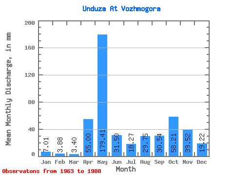
| Statistic | Jan | Feb | Mar | Apr | May | Jun | Jul | Aug | Sep | Oct | Nov | Dec | Annual |
|---|---|---|---|---|---|---|---|---|---|---|---|---|---|
| Mean | 7.01 | 3.92 | 3.39 | 55.00 | 179.37 | 31.49 | 18.25 | 29.74 | 30.53 | 58.21 | 39.51 | 19.21 | 471.55 |
| Standard Deviation | 4.92 | 2.57 | 1.98 | 50.94 | 77.48 | 24.91 | 17.31 | 39.65 | 23.34 | 38.90 | 24.07 | 16.98 | 134.69 |
| Min | 1.85 | 0.55 | 0.86 | 2.08 | 69.21 | 4.99 | 1.76 | 0.65 | 2.50 | 6.02 | 5.83 | 2.11 | 277.18 |
| Max | 19.77 | 11.36 | 9.89 | 164.34 | 299.18 | 128.98 | 67.92 | 183.98 | 82.38 | 140.56 | 88.62 | 80.38 | 880.61 |
| Coefficient of Variation | 0.70 | 0.65 | 0.58 | 0.93 | 0.43 | 0.79 | 0.95 | 1.33 | 0.77 | 0.67 | 0.61 | 0.88 | 0.29 |
 Return to R-Arctic Net Home Page