|
|
|||||||||||||||||
| Point ID: 7306 | Downloads | Plots | Site Data | Code: 49095 |
|
|
|||||||||||||||||
| Download | |
|---|---|
| Site Descriptor Information | Site Time Series Data |
| Link to all available data | |
|
|
| View: | Statistics | Time Series |
| Units: | m3/s |
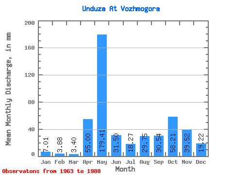
| Statistic | Jan | Feb | Mar | Apr | May | Jun | Jul | Aug | Sep | Oct | Nov | Dec | Annual |
|---|---|---|---|---|---|---|---|---|---|---|---|---|---|
| Mean | 7.01 | 3.92 | 3.39 | 55.00 | 179.37 | 31.49 | 18.25 | 29.74 | 30.53 | 58.21 | 39.51 | 19.21 | 471.55 |
| Standard Deviation | 4.92 | 2.57 | 1.98 | 50.94 | 77.48 | 24.91 | 17.31 | 39.65 | 23.34 | 38.90 | 24.07 | 16.98 | 134.69 |
| Min | 1.85 | 0.55 | 0.86 | 2.08 | 69.21 | 4.99 | 1.76 | 0.65 | 2.50 | 6.02 | 5.83 | 2.11 | 277.18 |
| Max | 19.77 | 11.36 | 9.89 | 164.34 | 299.18 | 128.98 | 67.92 | 183.98 | 82.38 | 140.56 | 88.62 | 80.38 | 880.61 |
| Coefficient of Variation | 0.70 | 0.65 | 0.58 | 0.93 | 0.43 | 0.79 | 0.95 | 1.33 | 0.77 | 0.67 | 0.61 | 0.88 | 0.29 |
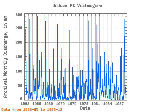
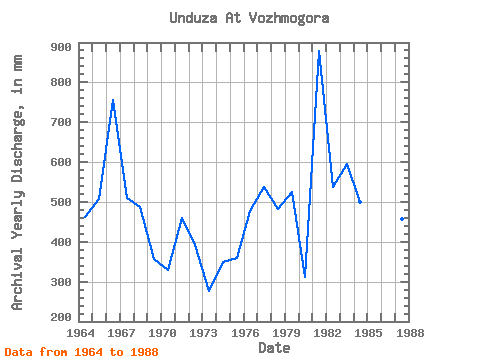
| Year | Jan | Feb | Mar | Apr | May | Jun | Jul | Aug | Sep | Oct | Nov | Dec | Annual | 1963 | 253.62 | 22.47 | 44.27 | 20.20 | 21.22 | 30.52 | 28.29 | 13.33 | 1964 | 11.18 | 9.01 | 5.59 | 35.78 | 288.00 | 34.12 | 11.18 | 6.45 | 5.41 | 25.79 | 23.30 | 11.61 | 463.10 | 1965 | 6.45 | 5.48 | 5.16 | 96.52 | 122.51 | 22.88 | 49.43 | 42.13 | 22.47 | 75.66 | 47.01 | 14.62 | 507.85 | 1966 | 8.60 | 3.92 | 3.01 | 14.15 | 299.18 | 38.69 | 67.92 | 39.55 | 56.17 | 140.56 | 69.06 | 23.64 | 756.92 | 1967 | 4.30 | 3.02 | 3.22 | 164.34 | 137.55 | 24.13 | 12.90 | 7.74 | 20.80 | 57.60 | 60.74 | 14.62 | 510.89 | 1968 | 6.45 | 3.13 | 4.30 | 21.64 | 280.70 | 18.31 | 19.34 | 12.47 | 25.80 | 62.76 | 25.38 | 14.19 | 488.85 | 1969 | 8.60 | 2.00 | 1.59 | 99.02 | 109.61 | 10.40 | 2.88 | 1.55 | 22.05 | 54.59 | 31.62 | 14.62 | 357.60 | 1970 | 4.00 | 2.70 | 1.59 | 19.14 | 182.26 | 7.49 | 1.93 | 1.33 | 41.19 | 54.16 | 12.06 | 4.00 | 328.77 | 1971 | 5.16 | 4.70 | 2.45 | 8.74 | 269.95 | 17.89 | 9.89 | 4.30 | 9.15 | 76.08 | 41.60 | 15.90 | 460.44 | 1972 | 5.16 | 2.70 | 2.67 | 23.71 | 184.41 | 33.28 | 5.16 | 2.49 | 7.91 | 21.49 | 25.38 | 80.38 | 390.87 | 1973 | 19.77 | 8.22 | 6.45 | 99.02 | 113.48 | 8.32 | 1.76 | 0.65 | 2.50 | 6.02 | 8.74 | 2.58 | 277.18 | 1974 | 1.85 | 1.65 | 2.45 | 7.07 | 248.46 | 39.52 | 7.74 | 7.74 | 3.25 | 13.33 | 13.73 | 7.31 | 349.96 | 1975 | 8.17 | 5.48 | 5.16 | 112.75 | 113.48 | 11.23 | 5.59 | 8.60 | 21.64 | 33.53 | 24.55 | 10.32 | 360.10 | 1976 | 2.54 | 2.12 | 1.93 | 41.60 | 122.51 | 39.52 | 44.27 | 68.78 | 82.38 | 34.39 | 23.71 | 15.47 | 476.95 | 1977 | 3.87 | 2.94 | 2.45 | 102.35 | 76.51 | 24.13 | 6.02 | 27.51 | 65.74 | 104.89 | 88.62 | 32.24 | 537.06 | 1978 | 7.31 | 2.86 | 2.67 | 18.72 | 96.72 | 36.61 | 21.49 | 55.88 | 71.14 | 73.08 | 71.98 | 25.79 | 482.31 | 1979 | 4.73 | 2.74 | 2.19 | 3.12 | 282.42 | 22.88 | 13.76 | 27.94 | 19.97 | 73.50 | 51.59 | 25.36 | 524.14 | 1980 | 6.02 | 3.52 | 3.57 | 32.87 | 183.98 | 27.46 | 20.63 | 2.32 | 6.24 | 11.18 | 9.57 | 7.74 | 312.26 | 1981 | 6.02 | 5.09 | 3.87 | 6.24 | 267.80 | 128.98 | 39.12 | 97.15 | 78.22 | 129.39 | 83.63 | 40.84 | 880.61 | 1982 | 16.34 | 3.17 | 2.36 | 83.63 | 155.18 | 47.43 | 17.19 | 32.67 | 34.95 | 28.80 | 71.56 | 45.56 | 537.23 | 1983 | 18.48 | 11.36 | 9.89 | 164.34 | 69.21 | 29.96 | 7.74 | 28.80 | 40.36 | 127.67 | 63.66 | 23.21 | 594.81 | 1984 | 9.89 | 6.27 | 5.16 | 101.52 | 139.70 | 4.99 | 3.78 | 37.83 | 39.94 | 117.78 | 30.37 | 4.73 | 499.32 | 1985 | 2.02 | 0.55 | 2.02 | 2.33 | 133.25 | 75.31 | 14.62 | 8.60 | 13.73 | 57.60 | 41.60 | 5.59 | 355.20 | 1986 | 2.45 | 1.45 | 1.46 | 86.54 | 87.26 | 38.69 | 6.88 | 1.38 | 20.39 | 46.42 | 44.10 | 33.10 | 369.80 | 1987 | 3.10 | 1.57 | 0.86 | 2.08 | 156.47 | 18.72 | 30.52 | 183.98 | 39.52 | 18.05 | 5.83 | 2.11 | 456.81 | 1988 | 2.79 | 2.47 | 2.79 | 27.88 | 289.29 | 35.36 | 8.60 | 45.13 | 21.64 | 38.69 | 29.54 | 10.75 | 509.66 |
|---|
 Return to R-Arctic Net Home Page