|
|
|||||||||||||||||
| Point ID: 7306 | Downloads | Plots | Site Data | Code: 49095 |
|
|
|||||||||||||||||
| Download | |
|---|---|
| Site Descriptor Information | Site Time Series Data |
| Link to all available data | |
| View: | Time Series | All |
| Units: | mm |
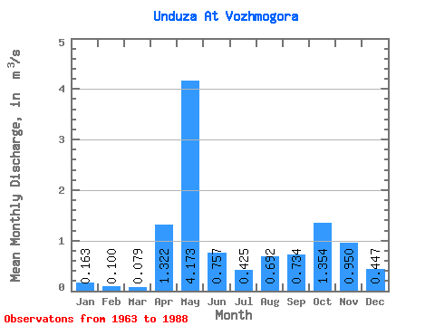
| Statistic | Jan | Feb | Mar | Apr | May | Jun | Jul | Aug | Sep | Oct | Nov | Dec | Annual |
|---|---|---|---|---|---|---|---|---|---|---|---|---|---|
| Mean | 0.16 | 0.10 | 0.08 | 1.32 | 4.17 | 0.76 | 0.42 | 0.69 | 0.73 | 1.35 | 0.95 | 0.45 | 0.93 |
| Standard Deviation | 0.11 | 0.07 | 0.05 | 1.22 | 1.80 | 0.60 | 0.40 | 0.92 | 0.56 | 0.91 | 0.58 | 0.40 | 0.27 |
| Min | 0.04 | 0.01 | 0.02 | 0.05 | 1.61 | 0.12 | 0.04 | 0.01 | 0.06 | 0.14 | 0.14 | 0.05 | 0.55 |
| Max | 0.46 | 0.29 | 0.23 | 3.95 | 6.96 | 3.10 | 1.58 | 4.28 | 1.98 | 3.27 | 2.13 | 1.87 | 1.74 |
| Coefficient of Variation | 0.70 | 0.65 | 0.58 | 0.93 | 0.43 | 0.79 | 0.95 | 1.33 | 0.77 | 0.67 | 0.61 | 0.88 | 0.29 |
 Return to R-Arctic Net Home Page