|
|
|||||||||||||||||
| Point ID: 7283 | Downloads | Plots | Site Data | Other Close Sites | Code: 49041 |
|
|
|||||||||||||||||
| Download | |
|---|---|
| Site Descriptor Information | Site Time Series Data |
| Link to all available data | |
| View: | Time Series | All |
| Units: | m3/s |
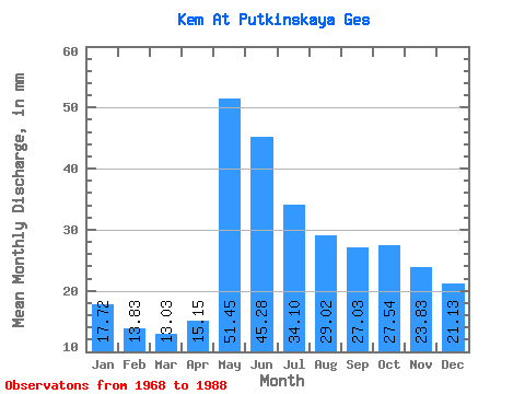
| Statistic | Jan | Feb | Mar | Apr | May | Jun | Jul | Aug | Sep | Oct | Nov | Dec | Annual |
|---|---|---|---|---|---|---|---|---|---|---|---|---|---|
| Mean | 17.72 | 13.95 | 13.03 | 15.15 | 51.45 | 45.28 | 34.09 | 29.02 | 27.03 | 27.54 | 23.84 | 21.12 | 318.46 |
| Standard Deviation | 4.24 | 3.82 | 3.30 | 6.57 | 15.20 | 12.63 | 11.68 | 10.43 | 10.26 | 8.62 | 7.94 | 6.11 | 51.49 |
| Min | 9.86 | 8.54 | 8.78 | 8.44 | 25.43 | 28.17 | 22.14 | 16.24 | 13.94 | 11.51 | 9.82 | 10.15 | 238.88 |
| Max | 25.04 | 21.58 | 20.40 | 33.41 | 83.72 | 73.27 | 72.32 | 57.81 | 58.30 | 49.40 | 37.24 | 32.77 | 439.30 |
| Coefficient of Variation | 0.24 | 0.27 | 0.25 | 0.43 | 0.29 | 0.28 | 0.34 | 0.36 | 0.38 | 0.31 | 0.33 | 0.29 | 0.16 |
| Other Close Sites | ||||||
|---|---|---|---|---|---|---|
| PointID | Latitude | Longitude | Drainage Area | Source | Name | |
| 7282 | "Kem At Poduzhem'e" | 64.90 | -2287324 | SHI | 18.00 | |
 Return to R-Arctic Net Home Page