|
|
|||||||||||||||||
| Point ID: 7283 | Downloads | Plots | Site Data | Other Close Sites | Code: 49041 |
|
|
|||||||||||||||||
| Download | |
|---|---|
| Site Descriptor Information | Site Time Series Data |
| Link to all available data | |
| View: | Time Series | All |
| Units: | mm |
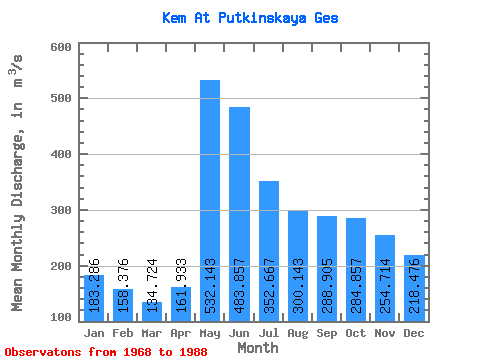
| Statistic | Jan | Feb | Mar | Apr | May | Jun | Jul | Aug | Sep | Oct | Nov | Dec | Annual |
|---|---|---|---|---|---|---|---|---|---|---|---|---|---|
| Mean | 183.29 | 158.38 | 134.72 | 161.93 | 532.14 | 483.86 | 352.67 | 300.14 | 288.90 | 284.86 | 254.71 | 218.48 | 279.51 |
| Standard Deviation | 43.84 | 43.38 | 34.14 | 70.22 | 157.17 | 134.97 | 120.78 | 107.92 | 109.63 | 89.21 | 84.88 | 63.15 | 45.20 |
| Min | 102.00 | 96.90 | 90.80 | 90.20 | 263.00 | 301.00 | 229.00 | 168.00 | 149.00 | 119.00 | 105.00 | 105.00 | 209.67 |
| Max | 259.00 | 245.00 | 211.00 | 357.00 | 866.00 | 783.00 | 748.00 | 598.00 | 623.00 | 511.00 | 398.00 | 339.00 | 385.57 |
| Coefficient of Variation | 0.24 | 0.27 | 0.25 | 0.43 | 0.29 | 0.28 | 0.34 | 0.36 | 0.38 | 0.31 | 0.33 | 0.29 | 0.16 |
| Other Close Sites | ||||||
|---|---|---|---|---|---|---|
| PointID | Latitude | Longitude | Drainage Area | Source | Name | |
| 7282 | "Kem At Poduzhem'e" | 64.90 | -2287324 | SHI | 18.00 | |
 Return to R-Arctic Net Home Page