|
|
|||||||||||||||||
| Point ID: 7282 | Downloads | Plots | Site Data | Other Close Sites | Code: 49039 |
|
|
|||||||||||||||||
| Download | |
|---|---|
| Site Descriptor Information | Site Time Series Data |
| Link to all available data | |
| View: | Time Series | All |
| Units: | m3/s |
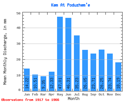
| Statistic | Jan | Feb | Mar | Apr | May | Jun | Jul | Aug | Sep | Oct | Nov | Dec | Annual |
|---|---|---|---|---|---|---|---|---|---|---|---|---|---|
| Mean | 14.21 | 10.60 | 9.35 | 12.33 | 47.00 | 46.31 | 35.23 | 26.05 | 23.71 | 26.25 | 23.74 | 18.19 | 289.86 |
| Standard Deviation | 5.29 | 3.96 | 3.18 | 6.95 | 15.83 | 15.94 | 12.18 | 9.94 | 9.48 | 10.71 | 10.47 | 8.00 | 73.59 |
| Min | 3.03 | 3.37 | 2.33 | 4.28 | 17.18 | 18.39 | 17.85 | 12.09 | 10.68 | 8.18 | 4.89 | 4.33 | 122.83 |
| Max | 29.66 | 24.05 | 17.09 | 35.67 | 90.51 | 73.30 | 62.10 | 56.54 | 47.57 | 53.56 | 50.63 | 38.20 | 446.16 |
| Coefficient of Variation | 0.37 | 0.37 | 0.34 | 0.56 | 0.34 | 0.34 | 0.35 | 0.38 | 0.40 | 0.41 | 0.44 | 0.44 | 0.25 |
| Other Close Sites | ||||||
|---|---|---|---|---|---|---|
| PointID | Latitude | Longitude | Drainage Area | Source | Name | |
| 7283 | "Kem At Putkinskaya GES" | 64.93 | -2279726 | SHI | 5.70 | |
 Return to R-Arctic Net Home Page