|
|
|||||||||||||||||
| Point ID: 7106 | Downloads | Plots | Site Data | Code: 11548 |
|
|
|||||||||||||||||
| Download | |
|---|---|
| Site Descriptor Information | Site Time Series Data |
| Link to all available data | |
| View: | Time Series | All |
| Units: | m3/s |
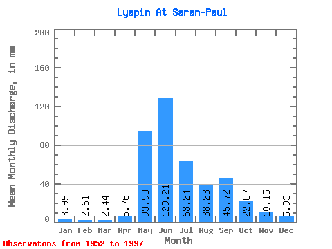
| Statistic | Jan | Feb | Mar | Apr | May | Jun | Jul | Aug | Sep | Oct | Nov | Dec | Annual |
|---|---|---|---|---|---|---|---|---|---|---|---|---|---|
| Mean | 3.95 | 2.63 | 2.44 | 5.76 | 93.96 | 129.21 | 63.23 | 38.22 | 45.73 | 22.87 | 10.15 | 5.93 | 423.01 |
| Standard Deviation | 0.90 | 0.67 | 0.59 | 8.87 | 47.13 | 54.95 | 30.98 | 21.34 | 23.93 | 8.21 | 3.01 | 1.31 | 79.08 |
| Min | 2.42 | 1.50 | 1.25 | 1.03 | 14.91 | 46.52 | 15.34 | 13.09 | 11.34 | 9.02 | 4.51 | 3.91 | 257.26 |
| Max | 6.34 | 4.18 | 3.89 | 54.64 | 186.74 | 256.40 | 147.65 | 112.62 | 109.56 | 46.90 | 19.05 | 9.05 | 589.35 |
| Coefficient of Variation | 0.23 | 0.26 | 0.24 | 1.54 | 0.50 | 0.42 | 0.49 | 0.56 | 0.52 | 0.36 | 0.30 | 0.22 | 0.19 |
 Return to R-Arctic Net Home Page