|
|
|||||||||||||||||
| Point ID: 7106 | Downloads | Plots | Site Data | Code: 11548 |
|
|
|||||||||||||||||
| Download | |
|---|---|
| Site Descriptor Information | Site Time Series Data |
| Link to all available data | |
|
|
| View: | Statistics | Time Series |
| Units: | m3/s |
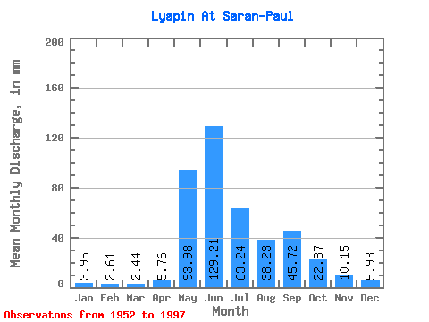
| Statistic | Jan | Feb | Mar | Apr | May | Jun | Jul | Aug | Sep | Oct | Nov | Dec | Annual |
|---|---|---|---|---|---|---|---|---|---|---|---|---|---|
| Mean | 3.95 | 2.63 | 2.44 | 5.76 | 93.96 | 129.21 | 63.23 | 38.22 | 45.73 | 22.87 | 10.15 | 5.93 | 423.01 |
| Standard Deviation | 0.90 | 0.67 | 0.59 | 8.87 | 47.13 | 54.95 | 30.98 | 21.34 | 23.93 | 8.21 | 3.01 | 1.31 | 79.08 |
| Min | 2.42 | 1.50 | 1.25 | 1.03 | 14.91 | 46.52 | 15.34 | 13.09 | 11.34 | 9.02 | 4.51 | 3.91 | 257.26 |
| Max | 6.34 | 4.18 | 3.89 | 54.64 | 186.74 | 256.40 | 147.65 | 112.62 | 109.56 | 46.90 | 19.05 | 9.05 | 589.35 |
| Coefficient of Variation | 0.23 | 0.26 | 0.24 | 1.54 | 0.50 | 0.42 | 0.49 | 0.56 | 0.52 | 0.36 | 0.30 | 0.22 | 0.19 |
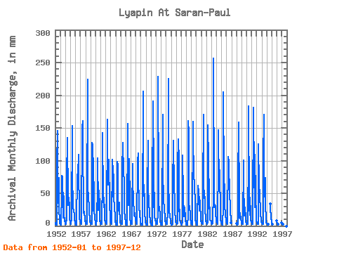
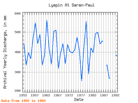
| Year | Jan | Feb | Mar | Apr | May | Jun | Jul | Aug | Sep | Oct | Nov | Dec | Annual | 1952 | 4.57 | 3.01 | 2.16 | 1.98 | 93.08 | 145.71 | 36.48 | 44.01 | 73.84 | 27.94 | 7.41 | 3.95 | 443.92 | 1953 | 2.42 | 2.00 | 2.08 | 54.64 | 79.62 | 75.80 | 28.37 | 13.27 | 45.81 | 19.98 | 7.43 | 4.85 | 336.43 | 1954 | 3.33 | 2.52 | 2.68 | 12.50 | 74.98 | 134.78 | 42.27 | 32.86 | 43.99 | 30.25 | 11.31 | 6.21 | 397.40 | 1955 | 4.46 | 3.14 | 2.52 | 11.36 | 157.78 | 70.61 | 37.64 | 27.07 | 25.36 | 16.21 | 7.97 | 5.73 | 367.29 | 1956 | 3.49 | 1.82 | 1.75 | 1.89 | 81.79 | 61.51 | 81.21 | 112.62 | 74.40 | 34.89 | 12.19 | 6.79 | 470.90 | 1957 | 5.01 | 3.25 | 2.74 | 2.84 | 156.34 | 161.12 | 134.19 | 20.70 | 24.66 | 22.00 | 10.66 | 6.82 | 547.27 | 1958 | 4.75 | 3.46 | 2.90 | 2.79 | 28.08 | 224.17 | 63.55 | 42.70 | 31.10 | 20.41 | 11.99 | 6.34 | 443.45 | 1959 | 3.84 | 3.07 | 2.91 | 2.17 | 131.15 | 124.70 | 86.28 | 24.32 | 67.25 | 26.49 | 11.57 | 6.11 | 488.07 | 1960 | 3.81 | 2.19 | 1.79 | 10.56 | 62.53 | 103.26 | 31.27 | 24.90 | 53.94 | 29.68 | 7.75 | 4.68 | 336.26 | 1961 | 3.58 | 2.37 | 2.50 | 2.41 | 77.16 | 142.91 | 43.14 | 29.53 | 43.99 | 22.58 | 8.79 | 5.72 | 384.46 | 1962 | 4.07 | 3.11 | 2.72 | 7.45 | 167.92 | 90.09 | 65.14 | 65.14 | 101.86 | 32.72 | 14.57 | 7.58 | 559.56 | 1963 | 4.40 | 3.22 | 2.55 | 2.30 | 104.95 | 82.66 | 45.74 | 81.79 | 40.21 | 33.15 | 11.25 | 6.47 | 415.94 | 1964 | 3.82 | 2.37 | 2.06 | 1.89 | 102.20 | 93.17 | 35.76 | 24.17 | 36.15 | 27.65 | 7.55 | 5.30 | 340.71 | 1965 | 4.10 | 2.48 | 2.50 | 2.80 | 86.85 | 127.22 | 82.95 | 91.78 | 61.79 | 25.33 | 12.16 | 6.62 | 504.38 | 1966 | 4.18 | 2.52 | 2.00 | 2.12 | 162.13 | 103.40 | 46.61 | 32.43 | 102.28 | 35.03 | 11.78 | 6.05 | 508.77 | 1967 | 3.65 | 2.47 | 3.10 | 20.04 | 98.58 | 65.57 | 44.44 | 17.80 | 15.55 | 20.99 | 19.05 | 9.05 | 318.70 | 1968 | 5.08 | 3.46 | 3.13 | 3.08 | 102.20 | 110.97 | 63.98 | 47.77 | 29.56 | 17.37 | 8.34 | 4.37 | 397.43 | 1969 | 3.37 | 1.93 | 1.72 | 1.61 | 14.91 | 205.96 | 82.37 | 47.62 | 48.76 | 18.67 | 9.23 | 4.89 | 441.98 | 1970 | 2.75 | 1.74 | 1.85 | 1.93 | 49.94 | 130.30 | 65.14 | 32.86 | 24.52 | 16.07 | 9.86 | 4.65 | 341.09 | 1971 | 2.56 | 1.54 | 1.25 | 1.03 | 51.82 | 190.55 | 79.18 | 28.95 | 51.42 | 15.05 | 8.83 | 5.21 | 437.92 | 1972 | 3.34 | 2.29 | 2.33 | 2.38 | 21.28 | 228.38 | 57.90 | 29.10 | 29.70 | 14.46 | 6.28 | 3.91 | 403.07 | 1973 | 2.42 | 1.50 | 1.31 | 6.08 | 176.60 | 88.83 | 37.64 | 31.41 | 24.94 | 13.78 | 8.29 | 5.30 | 395.29 | 1974 | 4.26 | 2.61 | 2.59 | 2.58 | 23.45 | 225.57 | 73.39 | 25.04 | 23.54 | 15.92 | 7.36 | 4.29 | 411.93 | 1975 | 3.21 | 1.94 | 2.10 | 2.80 | 76.29 | 115.87 | 135.06 | 58.34 | 42.73 | 22.44 | 8.77 | 6.47 | 473.21 | 1976 | 4.47 | 3.19 | 3.14 | 3.36 | 95.83 | 132.54 | 102.05 | 23.31 | 25.22 | 9.02 | 4.51 | 4.26 | 409.24 | 1977 | 2.49 | 1.53 | 1.56 | 6.26 | 111.46 | 46.52 | 15.34 | 19.98 | 28.30 | 12.25 | 8.03 | 5.12 | 257.26 | 1978 | 3.02 | 2.11 | 1.95 | 2.14 | 15.49 | 161.12 | 147.65 | 32.43 | 29.84 | 17.52 | 10.00 | 5.95 | 428.36 | 1979 | 4.24 | 2.62 | 2.04 | 2.61 | 165.02 | 122.59 | 93.66 | 52.98 | 69.21 | 26.93 | 10.14 | 5.53 | 554.50 | 1980 | 3.16 | 1.78 | 1.77 | 5.87 | 64.13 | 50.72 | 43.28 | 24.03 | 44.41 | 36.48 | 9.53 | 7.15 | 290.83 | 1981 | 5.23 | 3.93 | 3.50 | 3.03 | 53.99 | 170.93 | 44.15 | 55.59 | 35.03 | 24.61 | 12.47 | 8.16 | 420.67 | 1982 | 5.38 | 3.57 | 3.08 | 5.56 | 159.23 | 101.44 | 43.28 | 26.93 | 28.16 | 9.22 | 7.68 | 5.56 | 396.94 | 1983 | 4.23 | 2.82 | 2.43 | 3.54 | 55.44 | 256.40 | 45.02 | 29.53 | 33.07 | 29.96 | 18.91 | 8.92 | 491.92 | 1984 | 6.21 | 4.18 | 3.89 | 3.05 | 104.80 | 147.11 | 58.19 | 53.13 | 85.61 | 18.67 | 9.32 | 5.20 | 498.80 | 1985 | 3.16 | 2.04 | 1.68 | 1.89 | 30.98 | 204.56 | 72.23 | 60.65 | 32.65 | 16.21 | 9.74 | 6.33 | 442.49 | 1986 | 4.08 | 3.09 | 3.10 | 3.70 | 109.87 | 90.09 | 105.24 | 42.41 | 57.73 | 22.15 | 9.86 | 5.46 | 454.14 | 1988 | 3.91 | 2.15 | 2.11 | 2.82 | 66.59 | 158.32 | 36.62 | 13.09 | 11.34 | 20.99 | 9.82 | 6.04 | 333.95 | 1989 | 3.94 | 2.72 | 3.01 | 2.76 | 103.94 | 59.41 | 25.48 | 16.07 | 28.86 | 12.91 | 6.99 | 4.37 | 269.06 | 1990 | 3.19 | 2.52 | 2.39 | 4.85 | 117.40 | 183.54 | 28.95 | 16.94 | 43.99 | 19.11 | 9.67 | 5.69 | 438.50 | 1991 | 3.65 | 2.24 | 2.53 | 20.18 | 186.74 | 76.22 | 89.46 | 29.39 | 109.56 | 46.90 | 17.09 | 8.53 | 589.35 | 1992 | 4.81 | 3.54 | 3.33 | 3.12 | 129.27 | 61.93 | 76.14 | 38.80 | 32.37 | 17.37 | 10.35 | 6.37 | 384.29 | 1993 | 4.04 | 3.32 | 3.01 | 2.86 | 100.61 | 170.93 | 66.01 | 45.74 | 73.84 | 31.41 | 10.89 | 5.44 | 517.56 | 1994 | 3.92 | 2.31 | 2.03 | 3.14 | 33.91 | 29.68 | 10.98 | 7.24 | 1995 | 4.47 | 2.98 | 2.72 | 8.44 | 1996 | 6.34 | 3.52 | 2.92 | 4.92 | 1997 | 3.33 | 2.12 | 2.33 | 4.65 |
|---|
 Return to R-Arctic Net Home Page