|
|
|||||||||||||||||
| Point ID: 7106 | Downloads | Plots | Site Data | Code: 11548 |
|
|
|||||||||||||||||
| Download | |
|---|---|
| Site Descriptor Information | Site Time Series Data |
| Link to all available data | |
| View: | Time Series | All |
| Units: | mm |
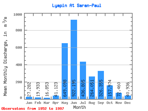
| Statistic | Jan | Feb | Mar | Apr | May | Jun | Jul | Aug | Sep | Oct | Nov | Dec | Annual |
|---|---|---|---|---|---|---|---|---|---|---|---|---|---|
| Mean | 27.28 | 19.93 | 16.85 | 41.12 | 649.10 | 922.20 | 436.81 | 264.05 | 326.36 | 157.97 | 72.46 | 40.94 | 247.96 |
| Standard Deviation | 6.21 | 5.08 | 4.11 | 63.29 | 325.60 | 392.16 | 213.98 | 147.46 | 170.79 | 56.73 | 21.50 | 9.06 | 46.35 |
| Min | 16.70 | 11.40 | 8.65 | 7.36 | 103.00 | 332.00 | 106.00 | 90.40 | 80.90 | 62.30 | 32.20 | 27.00 | 150.80 |
| Max | 43.80 | 31.70 | 26.90 | 390.00 | 1290.00 | 1830.00 | 1020.00 | 778.00 | 782.00 | 324.00 | 136.00 | 62.50 | 345.47 |
| Coefficient of Variation | 0.23 | 0.26 | 0.24 | 1.54 | 0.50 | 0.42 | 0.49 | 0.56 | 0.52 | 0.36 | 0.30 | 0.22 | 0.19 |
 Return to R-Arctic Net Home Page