|
|
|||||||||||||||||
| Point ID: 7092 | Downloads | Plots | Site Data | Other Close Sites | Code: 11522 |
|
|
|||||||||||||||||
| Download | |
|---|---|
| Site Descriptor Information | Site Time Series Data |
| Link to all available data | |
| View: | Time Series | All |
| Units: | m3/s |
| Statistic | Jan | Feb | Mar | Apr | May | Jun | Jul | Aug | Sep | Oct | Nov | Dec | Annual |
|---|---|---|---|---|---|---|---|---|---|---|---|---|---|
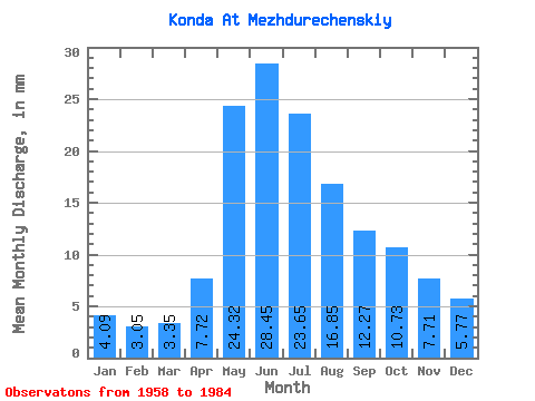
| Mean | 4.09 | 3.08 | 3.35 | 7.72 | 24.32 | 28.45 | 23.64 | 16.85 | 12.27 | 10.73 | 7.71 | 5.77 | 150.35 |
| Standard Deviation | 1.64 | 0.69 | 0.54 | 2.77 | 6.95 | 9.87 | 9.32 | 8.32 | 6.91 | 5.25 | 3.69 | 2.63 | 45.15 |
| Min | 2.54 | 2.01 | 2.29 | 2.98 | 13.32 | 10.44 | 6.43 | 5.43 | 5.52 | 5.00 | 3.19 | 2.98 | 72.81 |
| Max | 8.58 | 4.62 | 4.43 | 13.15 | 36.40 | 48.19 | 38.61 | 37.96 | 29.76 | 25.02 | 18.62 | 12.61 | 235.42 |
| Coefficient of Variation | 0.40 | 0.23 | 0.16 | 0.36 | 0.29 | 0.35 | 0.39 | 0.49 | 0.56 | 0.49 | 0.48 | 0.46 | 0.30 |
| Other Close Sites | ||||||
|---|---|---|---|---|---|---|
| PointID | Latitude | Longitude | Drainage Area | Source | Name | |
| 7091 | "Konda At Yuray" | 60.15 | -1395800 | SHI | 674.00 | |
 Return to R-Arctic Net Home Page