|
|
|||||||||||||||||
| Point ID: 7091 | Downloads | Plots | Site Data | Other Close Sites | Code: 11521 |
|
|
|||||||||||||||||
| Download | |
|---|---|
| Site Descriptor Information | Site Time Series Data |
| Link to all available data | |
| View: | Time Series | All |
| Units: | m3/s |
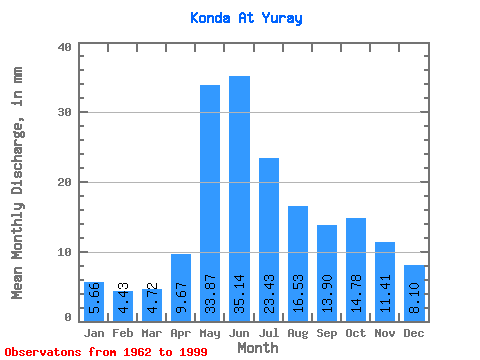
| Statistic | Jan | Feb | Mar | Apr | May | Jun | Jul | Aug | Sep | Oct | Nov | Dec | Annual |
|---|---|---|---|---|---|---|---|---|---|---|---|---|---|
| Mean | 5.66 | 4.46 | 4.72 | 9.67 | 33.87 | 35.14 | 23.43 | 16.53 | 13.90 | 14.78 | 11.41 | 8.10 | 181.39 |
| Standard Deviation | 2.47 | 1.40 | 1.35 | 4.47 | 10.72 | 10.95 | 9.62 | 7.98 | 6.35 | 7.50 | 5.62 | 4.49 | 47.97 |
| Min | 3.35 | 3.08 | 0.44 | 4.24 | 15.91 | 11.30 | 7.31 | 4.71 | 5.09 | 5.33 | 4.03 | 3.51 | 87.96 |
| Max | 15.91 | 9.61 | 7.76 | 21.71 | 52.07 | 53.83 | 47.27 | 32.96 | 26.81 | 36.74 | 25.70 | 25.18 | 252.32 |
| Coefficient of Variation | 0.44 | 0.31 | 0.29 | 0.46 | 0.32 | 0.31 | 0.41 | 0.48 | 0.46 | 0.51 | 0.49 | 0.55 | 0.26 |
| Other Close Sites | ||||||
|---|---|---|---|---|---|---|
| PointID | Latitude | Longitude | Drainage Area | Source | Name | |
| 7092 | "Konda At Mezhdurechenskiy" | 60.15 | -1395800 | SHI | 506.00 | |
 Return to R-Arctic Net Home Page