|
|
|||||||||||||||||
| Point ID: 7091 | Downloads | Plots | Site Data | Other Close Sites | Code: 11521 |
|
|
|||||||||||||||||
| Download | |
|---|---|
| Site Descriptor Information | Site Time Series Data |
| Link to all available data | |
| View: | Time Series | All |
| Units: | mm |
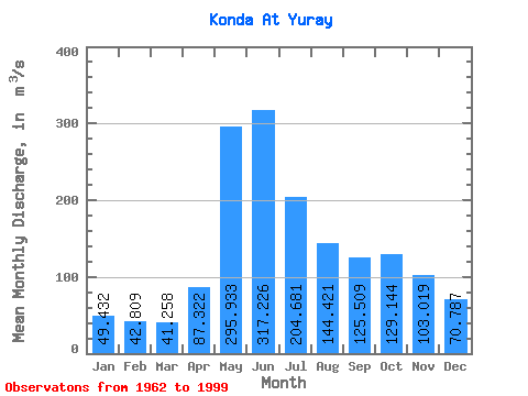
| Statistic | Jan | Feb | Mar | Apr | May | Jun | Jul | Aug | Sep | Oct | Nov | Dec | Annual |
|---|---|---|---|---|---|---|---|---|---|---|---|---|---|
| Mean | 49.43 | 42.81 | 41.26 | 87.32 | 295.93 | 317.23 | 204.68 | 144.42 | 125.51 | 129.14 | 103.02 | 70.79 | 134.49 |
| Standard Deviation | 21.61 | 13.39 | 11.80 | 40.38 | 93.67 | 98.85 | 84.09 | 69.71 | 57.32 | 65.58 | 50.74 | 39.25 | 35.57 |
| Min | 29.30 | 29.50 | 3.81 | 38.30 | 139.00 | 102.00 | 63.90 | 41.20 | 46.00 | 46.60 | 36.40 | 30.70 | 65.22 |
| Max | 139.00 | 92.20 | 67.80 | 196.00 | 455.00 | 486.00 | 413.00 | 288.00 | 242.00 | 321.00 | 232.00 | 220.00 | 187.08 |
| Coefficient of Variation | 0.44 | 0.31 | 0.29 | 0.46 | 0.32 | 0.31 | 0.41 | 0.48 | 0.46 | 0.51 | 0.49 | 0.55 | 0.26 |
| Other Close Sites | ||||||
|---|---|---|---|---|---|---|
| PointID | Latitude | Longitude | Drainage Area | Source | Name | |
| 7092 | "Konda At Mezhdurechenskiy" | 60.15 | -1395800 | SHI | 506.00 | |
 Return to R-Arctic Net Home Page