|
|
|||||||||||||||||
| Point ID: 7092 | Downloads | Plots | Site Data | Other Close Sites | Code: 11522 |
|
|
|||||||||||||||||
| Download | |
|---|---|
| Site Descriptor Information | Site Time Series Data |
| Link to all available data | |
| View: | Time Series | All |
| Units: | mm |
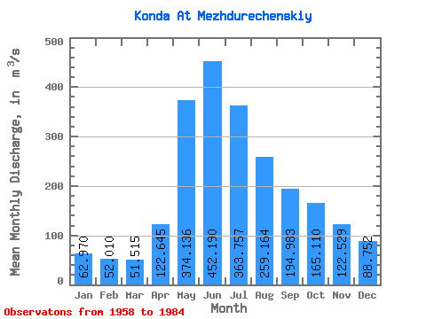
| Statistic | Jan | Feb | Mar | Apr | May | Jun | Jul | Aug | Sep | Oct | Nov | Dec | Annual |
|---|---|---|---|---|---|---|---|---|---|---|---|---|---|
| Mean | 62.97 | 52.01 | 51.52 | 122.64 | 374.14 | 452.19 | 363.76 | 259.16 | 194.98 | 165.11 | 122.53 | 88.75 | 196.28 |
| Standard Deviation | 25.25 | 11.70 | 8.31 | 44.02 | 106.91 | 156.82 | 143.42 | 127.94 | 109.84 | 80.76 | 58.63 | 40.43 | 58.94 |
| Min | 39.00 | 34.00 | 35.20 | 47.40 | 205.00 | 166.00 | 98.90 | 83.60 | 87.80 | 76.90 | 50.70 | 45.80 | 95.05 |
| Max | 132.00 | 78.10 | 68.10 | 209.00 | 560.00 | 766.00 | 594.00 | 584.00 | 473.00 | 385.00 | 296.00 | 194.00 | 307.32 |
| Coefficient of Variation | 0.40 | 0.23 | 0.16 | 0.36 | 0.29 | 0.35 | 0.39 | 0.49 | 0.56 | 0.49 | 0.48 | 0.46 | 0.30 |
| Other Close Sites | ||||||
|---|---|---|---|---|---|---|
| PointID | Latitude | Longitude | Drainage Area | Source | Name | |
| 7091 | "Konda At Yuray" | 60.15 | -1395800 | SHI | 674.00 | |
 Return to R-Arctic Net Home Page