|
|
|||||||||||||||||
| Point ID: 703 | Downloads | Plots | Site Data | Other Close Sites | Code: 07DA001 |
|
|
|||||||||||||||||
| Download | |
|---|---|
| Site Descriptor Information | Site Time Series Data |
| Link to all available data | |
| View: | Time Series | All |
| Units: | m3/s |
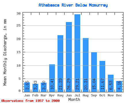
| Statistic | Jan | Feb | Mar | Apr | May | Jun | Jul | Aug | Sep | Oct | Nov | Dec | Annual |
|---|---|---|---|---|---|---|---|---|---|---|---|---|---|
| Mean | 3.59 | 3.01 | 3.44 | 10.26 | 21.01 | 25.89 | 28.77 | 20.00 | 14.81 | 11.49 | 6.44 | 4.10 | 153.61 |
| Standard Deviation | 0.87 | 0.67 | 0.76 | 4.09 | 7.56 | 7.60 | 8.67 | 5.26 | 4.75 | 3.59 | 1.86 | 1.10 | 31.91 |
| Min | 2.03 | 1.93 | 2.15 | 4.15 | 9.77 | 13.08 | 14.72 | 11.21 | 8.03 | 5.50 | 3.02 | 2.15 | 106.23 |
| Max | 5.25 | 4.88 | 5.46 | 20.07 | 41.88 | 43.07 | 55.17 | 35.03 | 29.43 | 20.94 | 12.38 | 7.11 | 239.27 |
| Coefficient of Variation | 0.24 | 0.22 | 0.22 | 0.40 | 0.36 | 0.29 | 0.30 | 0.26 | 0.32 | 0.31 | 0.29 | 0.27 | 0.21 |
| Other Close Sites | ||||||
|---|---|---|---|---|---|---|
| PointID | Latitude | Longitude | Drainage Area | Source | Name | |
| 695 | "CLEARWATER RIVER AT DRAPER" | 56.68 | 1324043 | Hydat | ||
 Return to R-Arctic Net Home Page