|
|
|||||||||||||||||
| Point ID: 695 | Downloads | Plots | Site Data | Other Close Sites | Code: 07CD001 |
|
|
|||||||||||||||||
| Download | |
|---|---|
| Site Descriptor Information | Site Time Series Data |
| Link to all available data | |
| View: | Time Series | All |
| Units: | m3/s |
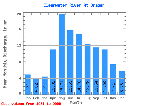
| Statistic | Jan | Feb | Mar | Apr | May | Jun | Jul | Aug | Sep | Oct | Nov | Dec | Annual |
|---|---|---|---|---|---|---|---|---|---|---|---|---|---|
| Mean | 4.91 | 4.05 | 4.44 | 11.02 | 19.70 | 15.65 | 14.76 | 12.28 | 11.54 | 11.00 | 7.41 | 5.76 | 122.03 |
| Standard Deviation | 1.31 | 0.95 | 0.79 | 4.95 | 7.91 | 6.61 | 7.91 | 6.40 | 6.72 | 5.18 | 2.69 | 1.78 | 36.03 |
| Min | 2.79 | 2.32 | 2.58 | 4.20 | 8.50 | 6.61 | 5.24 | 4.18 | 3.71 | 4.14 | 3.38 | 3.35 | 58.16 |
| Max | 7.82 | 6.20 | 6.51 | 26.17 | 42.43 | 40.23 | 40.60 | 30.26 | 36.19 | 24.52 | 14.73 | 10.43 | 220.29 |
| Coefficient of Variation | 0.27 | 0.23 | 0.18 | 0.45 | 0.40 | 0.42 | 0.54 | 0.52 | 0.58 | 0.47 | 0.36 | 0.31 | 0.29 |
| Other Close Sites | ||||||
|---|---|---|---|---|---|---|
| PointID | Latitude | Longitude | Drainage Area | Source | Name | |
| 703 | "ATHABASCA RIVER BELOW MCMURRAY" | 56.78 | 1329065 | Hydat | ||
 Return to R-Arctic Net Home Page