|
|
|||||||||||||||||
| Point ID: 695 | Downloads | Plots | Site Data | Other Close Sites | Code: 07CD001 |
|
|
|||||||||||||||||
| Download | |
|---|---|
| Site Descriptor Information | Site Time Series Data |
| Link to all available data | |
| View: | Time Series | All |
| Units: | mm |
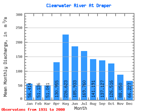
| Statistic | Jan | Feb | Mar | Apr | May | Jun | Jul | Aug | Sep | Oct | Nov | Dec | Annual |
|---|---|---|---|---|---|---|---|---|---|---|---|---|---|
| Mean | 56.41 | 51.14 | 51.04 | 130.96 | 226.62 | 185.93 | 169.76 | 141.19 | 137.13 | 126.52 | 88.05 | 66.23 | 119.10 |
| Standard Deviation | 15.02 | 12.00 | 9.12 | 58.83 | 91.02 | 78.55 | 90.91 | 73.62 | 79.82 | 59.57 | 31.98 | 20.46 | 35.16 |
| Min | 32.10 | 29.30 | 29.70 | 49.90 | 97.80 | 78.50 | 60.30 | 48.10 | 44.10 | 47.60 | 40.10 | 38.50 | 56.76 |
| Max | 89.90 | 78.30 | 74.90 | 311.00 | 488.00 | 478.00 | 467.00 | 348.00 | 430.00 | 282.00 | 175.00 | 120.00 | 214.98 |
| Coefficient of Variation | 0.27 | 0.23 | 0.18 | 0.45 | 0.40 | 0.42 | 0.54 | 0.52 | 0.58 | 0.47 | 0.36 | 0.31 | 0.29 |
| Other Close Sites | ||||||
|---|---|---|---|---|---|---|
| PointID | Latitude | Longitude | Drainage Area | Source | Name | |
| 703 | "ATHABASCA RIVER BELOW MCMURRAY" | 56.78 | 1329065 | Hydat | ||
 Return to R-Arctic Net Home Page