|
|
|||||||||||||||||
| Point ID: 703 | Downloads | Plots | Site Data | Other Close Sites | Code: 07DA001 |
|
|
|||||||||||||||||
| Download | |
|---|---|
| Site Descriptor Information | Site Time Series Data |
| Link to all available data | |
| View: | Time Series | All |
| Units: | mm |
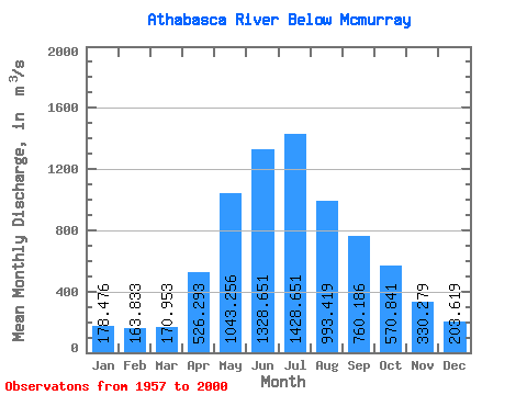
| Statistic | Jan | Feb | Mar | Apr | May | Jun | Jul | Aug | Sep | Oct | Nov | Dec | Annual |
|---|---|---|---|---|---|---|---|---|---|---|---|---|---|
| Mean | 178.48 | 163.83 | 170.95 | 526.29 | 1043.26 | 1328.65 | 1428.65 | 993.42 | 760.19 | 570.84 | 330.28 | 203.62 | 647.35 |
| Standard Deviation | 43.28 | 36.56 | 37.86 | 209.65 | 375.57 | 389.77 | 430.39 | 261.13 | 243.78 | 178.38 | 95.29 | 54.76 | 134.48 |
| Min | 101.00 | 105.00 | 107.00 | 213.00 | 485.00 | 671.00 | 731.00 | 557.00 | 412.00 | 273.00 | 155.00 | 107.00 | 447.67 |
| Max | 261.00 | 266.00 | 271.00 | 1030.00 | 2080.00 | 2210.00 | 2740.00 | 1740.00 | 1510.00 | 1040.00 | 635.00 | 353.00 | 1008.33 |
| Coefficient of Variation | 0.24 | 0.22 | 0.22 | 0.40 | 0.36 | 0.29 | 0.30 | 0.26 | 0.32 | 0.31 | 0.29 | 0.27 | 0.21 |
| Other Close Sites | ||||||
|---|---|---|---|---|---|---|
| PointID | Latitude | Longitude | Drainage Area | Source | Name | |
| 695 | "CLEARWATER RIVER AT DRAPER" | 56.68 | 1324043 | Hydat | ||
 Return to R-Arctic Net Home Page