|
|
|||||||||||||||||
| Point ID: 6988 | Downloads | Plots | Site Data | Code: 11207 |
|
|
|||||||||||||||||
| Download | |
|---|---|
| Site Descriptor Information | Site Time Series Data |
| Link to all available data | |
| View: | Time Series | All |
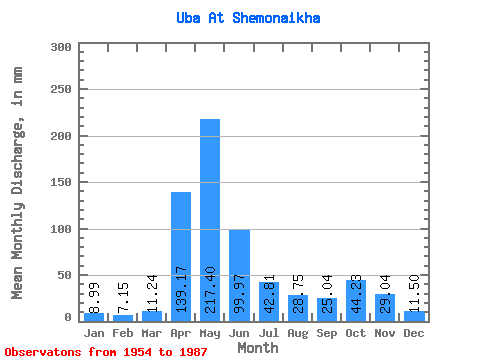
| Units: | m3/s |
| Statistic | Jan | Feb | Mar | Apr | May | Jun | Jul | Aug | Sep | Oct | Nov | Dec | Annual |
|---|---|---|---|---|---|---|---|---|---|---|---|---|---|
| Mean | 8.99 | 7.21 | 11.23 | 139.18 | 217.37 | 99.97 | 42.80 | 28.74 | 25.04 | 44.22 | 29.04 | 11.50 | 662.47 |
| Standard Deviation | 2.86 | 2.24 | 6.05 | 44.54 | 73.30 | 57.59 | 24.81 | 17.62 | 14.16 | 25.19 | 22.04 | 3.97 | 153.31 |
| Min | 3.73 | 2.22 | 3.86 | 71.00 | 77.46 | 19.52 | 11.63 | 7.56 | 8.63 | 13.72 | 7.96 | 6.89 | 455.20 |
| Max | 14.64 | 13.02 | 37.94 | 233.19 | 366.76 | 277.56 | 103.39 | 75.88 | 78.95 | 117.93 | 134.34 | 23.02 | 951.30 |
| Coefficient of Variation | 0.32 | 0.31 | 0.54 | 0.32 | 0.34 | 0.58 | 0.58 | 0.61 | 0.57 | 0.57 | 0.76 | 0.35 | 0.23 |
 Return to R-Arctic Net Home Page