|
|
|||||||||||||||||
| Point ID: 6988 | Downloads | Plots | Site Data | Code: 11207 |
|
|
|||||||||||||||||
| Download | |
|---|---|
| Site Descriptor Information | Site Time Series Data |
| Link to all available data | |
| View: | Time Series | All |
| Units: | mm |
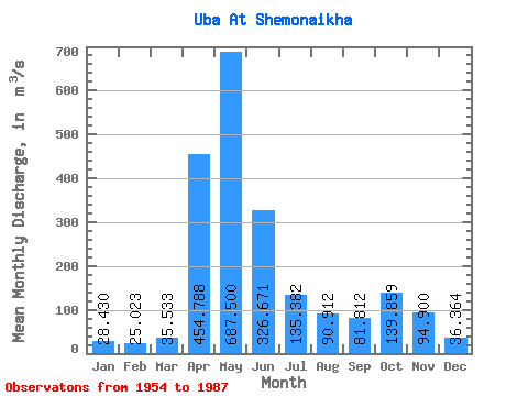
| Statistic | Jan | Feb | Mar | Apr | May | Jun | Jul | Aug | Sep | Oct | Nov | Dec | Annual |
|---|---|---|---|---|---|---|---|---|---|---|---|---|---|
| Mean | 28.43 | 25.02 | 35.53 | 454.79 | 687.50 | 326.67 | 135.38 | 90.91 | 81.81 | 139.86 | 94.90 | 36.36 | 177.79 |
| Standard Deviation | 9.05 | 7.79 | 19.15 | 145.55 | 231.82 | 188.20 | 78.47 | 55.72 | 46.28 | 79.67 | 72.02 | 12.57 | 41.14 |
| Min | 11.80 | 7.72 | 12.20 | 232.00 | 245.00 | 63.80 | 36.80 | 23.90 | 28.20 | 43.40 | 26.00 | 21.80 | 122.17 |
| Max | 46.30 | 45.20 | 120.00 | 762.00 | 1160.00 | 907.00 | 327.00 | 240.00 | 258.00 | 373.00 | 439.00 | 72.80 | 255.31 |
| Coefficient of Variation | 0.32 | 0.31 | 0.54 | 0.32 | 0.34 | 0.58 | 0.58 | 0.61 | 0.57 | 0.57 | 0.76 | 0.35 | 0.23 |
 Return to R-Arctic Net Home Page