|
|
|||||||||||||||||
| Point ID: 6988 | Downloads | Plots | Site Data | Code: 11207 |
|
|
|||||||||||||||||
| Download | |
|---|---|
| Site Descriptor Information | Site Time Series Data |
| Link to all available data | |
|
|
| View: | Statistics | Time Series |
| Units: | m3/s |
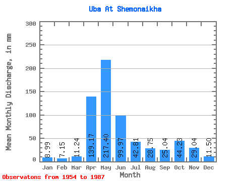
| Statistic | Jan | Feb | Mar | Apr | May | Jun | Jul | Aug | Sep | Oct | Nov | Dec | Annual |
|---|---|---|---|---|---|---|---|---|---|---|---|---|---|
| Mean | 8.99 | 7.21 | 11.23 | 139.18 | 217.37 | 99.97 | 42.80 | 28.74 | 25.04 | 44.22 | 29.04 | 11.50 | 662.47 |
| Standard Deviation | 2.86 | 2.24 | 6.05 | 44.54 | 73.30 | 57.59 | 24.81 | 17.62 | 14.16 | 25.19 | 22.04 | 3.97 | 153.31 |
| Min | 3.73 | 2.22 | 3.86 | 71.00 | 77.46 | 19.52 | 11.63 | 7.56 | 8.63 | 13.72 | 7.96 | 6.89 | 455.20 |
| Max | 14.64 | 13.02 | 37.94 | 233.19 | 366.76 | 277.56 | 103.39 | 75.88 | 78.95 | 117.93 | 134.34 | 23.02 | 951.30 |
| Coefficient of Variation | 0.32 | 0.31 | 0.54 | 0.32 | 0.34 | 0.58 | 0.58 | 0.61 | 0.57 | 0.57 | 0.76 | 0.35 | 0.23 |
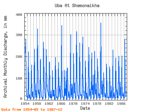
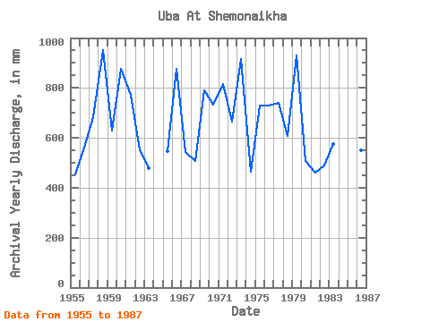
| Year | Jan | Feb | Mar | Apr | May | Jun | Jul | Aug | Sep | Oct | Nov | Dec | Annual | 1954 | 225.12 | 277.56 | 78.73 | 25.26 | 34.27 | 15.56 | 17.50 | 9.42 | 1955 | 6.51 | 6.42 | 12.27 | 81.71 | 229.54 | 33.05 | 11.63 | 7.56 | 25.64 | 20.55 | 8.97 | 14.07 | 455.20 | 1956 | 5.38 | 5.04 | 6.54 | 107.41 | 166.94 | 121.49 | 29.06 | 15.84 | 36.72 | 38.57 | 16.68 | 11.07 | 560.37 | 1957 | 8.98 | 6.42 | 8.25 | 85.69 | 242.82 | 115.68 | 44.26 | 71.45 | 13.34 | 34.46 | 43.76 | 13.03 | 684.86 | 1958 | 12.77 | 9.10 | 9.96 | 145.36 | 338.31 | 175.66 | 103.39 | 43.32 | 28.18 | 48.69 | 27.08 | 13.47 | 951.30 | 1959 | 10.05 | 9.07 | 10.88 | 174.43 | 194.45 | 96.70 | 50.27 | 29.75 | 15.27 | 15.68 | 11.78 | 10.24 | 627.91 | 1960 | 11.92 | 8.59 | 6.51 | 88.13 | 274.44 | 209.62 | 95.48 | 75.88 | 35.19 | 37.94 | 26.47 | 11.63 | 878.55 | 1961 | 12.33 | 8.73 | 16.22 | 233.19 | 175.16 | 59.98 | 72.09 | 58.81 | 41.92 | 43.32 | 28.80 | 23.02 | 772.39 | 1962 | 14.64 | 10.26 | 17.89 | 173.82 | 180.85 | 52.64 | 15.62 | 10.02 | 8.63 | 42.37 | 13.43 | 11.16 | 550.53 | 1963 | 11.67 | 8.47 | 21.63 | 71.00 | 140.38 | 75.89 | 18.56 | 17.93 | 18.45 | 46.16 | 41.62 | 7.90 | 478.62 | 1964 | 4.17 | 2.22 | 3.86 | 119.65 | 202.35 | 81.10 | 21.18 | 16.03 | 9.46 | 13.72 | 1965 | 6.01 | 5.30 | 6.36 | 112.62 | 178.01 | 37.03 | 14.86 | 45.53 | 42.84 | 66.08 | 28.37 | 6.89 | 547.74 | 1966 | 6.42 | 6.22 | 10.69 | 156.99 | 354.12 | 199.83 | 67.66 | 26.21 | 12.95 | 15.02 | 17.35 | 7.94 | 878.80 | 1967 | 4.14 | 2.59 | 10.72 | 136.79 | 77.46 | 19.52 | 54.07 | 35.41 | 20.81 | 39.84 | 134.34 | 7.65 | 544.01 | 1968 | 3.73 | 2.77 | 37.94 | 147.81 | 144.49 | 37.95 | 36.68 | 13.31 | 23.14 | 39.21 | 11.78 | 11.07 | 508.19 | 1969 | 6.83 | 7.89 | 8.13 | 130.37 | 312.06 | 116.29 | 30.16 | 15.40 | 30.17 | 75.57 | 49.58 | 9.77 | 789.40 | 1970 | 10.15 | 7.06 | 8.79 | 131.28 | 221.01 | 117.21 | 33.52 | 37.94 | 78.95 | 51.54 | 26.13 | 9.36 | 731.99 | 1971 | 7.68 | 7.89 | 10.69 | 193.10 | 325.66 | 119.96 | 45.84 | 35.41 | 23.23 | 20.05 | 21.21 | 7.21 | 815.67 | 1972 | 10.53 | 5.96 | 7.21 | 131.59 | 271.59 | 85.69 | 53.75 | 21.28 | 25.06 | 21.28 | 24.45 | 8.09 | 663.80 | 1973 | 10.81 | 8.04 | 10.78 | 225.84 | 300.05 | 136.49 | 72.09 | 50.90 | 21.48 | 42.37 | 27.63 | 12.74 | 916.93 | 1974 | 6.04 | 5.30 | 7.24 | 179.94 | 123.62 | 40.09 | 13.60 | 8.13 | 31.83 | 31.33 | 7.96 | 8.92 | 464.64 | 1975 | 8.22 | 5.53 | 5.79 | 112.31 | 250.73 | 175.96 | 34.46 | 16.41 | 28.15 | 51.85 | 29.99 | 10.78 | 728.92 | 1976 | 9.52 | 7.03 | 8.73 | 164.03 | 223.85 | 47.74 | 64.82 | 26.08 | 30.08 | 117.93 | 24.02 | 8.41 | 728.45 | 1977 | 5.09 | 8.41 | 12.46 | 224.31 | 215.31 | 63.04 | 30.57 | 48.69 | 24.05 | 78.41 | 20.93 | 11.32 | 740.93 | 1978 | 9.87 | 5.99 | 12.17 | 189.43 | 120.78 | 129.14 | 29.91 | 29.09 | 10.80 | 30.80 | 25.61 | 14.77 | 609.59 | 1979 | 11.00 | 7.46 | 9.33 | 93.03 | 366.76 | 134.96 | 87.26 | 33.83 | 25.68 | 90.74 | 56.92 | 20.52 | 931.52 | 1980 | 13.31 | 13.02 | 17.04 | 126.08 | 117.30 | 85.99 | 36.36 | 23.24 | 12.70 | 15.87 | 30.60 | 16.66 | 508.64 | 1981 | 11.73 | 8.24 | 14.35 | 165.25 | 139.12 | 42.54 | 20.90 | 12.11 | 9.58 | 16.16 | 10.89 | 8.66 | 459.52 | 1982 | 10.81 | 10.00 | 9.87 | 152.40 | 134.37 | 39.78 | 11.89 | 9.30 | 10.68 | 65.76 | 25.58 | 9.77 | 489.83 | 1983 | 8.85 | 6.68 | 10.15 | 83.54 | 237.13 | 95.17 | 22.99 | 10.31 | 23.81 | 33.52 | 33.66 | 10.65 | 574.47 | 1984 | 8.47 | 6.45 | 9.80 | 72.22 | 199.82 | 74.36 | 39.21 | 41.42 | 10.16 | 47.43 | 26.53 | 10.59 | 543.26 | 1985 | 11.32 | 9.36 | 9.61 | 154.54 | 208.04 | 108.94 | 43.00 | 28.08 | 20.04 | 85.37 | 36.42 | 11.07 | 724.10 | 1986 | 9.42 | 7.98 | 9.36 | 96.09 | 209.94 | 93.64 | 25.01 | 19.03 | 18.36 | 35.09 | 18.33 | 9.96 | 550.47 | 1987 | 8.25 | 8.35 | 9.55 | 132.81 | 288.98 | 98.23 | 46.48 | 18.34 | 49.58 | 75.25 | 33.97 | 21.59 | 788.25 |
|---|
 Return to R-Arctic Net Home Page