|
|
|||||||||||||||||
| Point ID: 6980 | Downloads | Plots | Site Data | Code: 11147 |
|
|
|||||||||||||||||
| Download | |
|---|---|
| Site Descriptor Information | Site Time Series Data |
| Link to all available data | |
| View: | Time Series | All |
| Units: | m3/s |
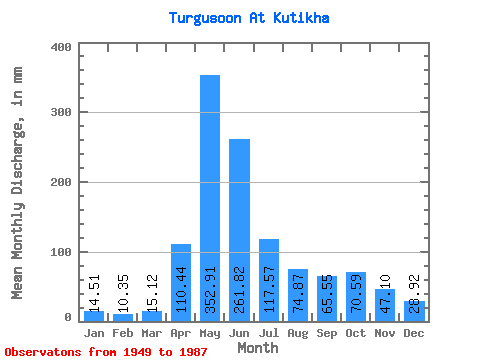
| Statistic | Jan | Feb | Mar | Apr | May | Jun | Jul | Aug | Sep | Oct | Nov | Dec | Annual |
|---|---|---|---|---|---|---|---|---|---|---|---|---|---|
| Mean | 14.51 | 10.44 | 15.12 | 110.44 | 352.86 | 261.81 | 117.56 | 74.86 | 65.55 | 70.58 | 47.10 | 28.92 | 1191.53 |
| Standard Deviation | 6.50 | 4.37 | 6.96 | 49.31 | 102.38 | 142.32 | 60.16 | 35.91 | 32.08 | 36.23 | 17.60 | 13.93 | 288.49 |
| Min | 4.98 | 1.71 | 2.28 | 27.00 | 182.77 | 61.78 | 27.67 | 16.63 | 12.44 | 19.46 | 14.82 | 4.11 | 580.79 |
| Max | 35.93 | 25.21 | 29.90 | 241.92 | 618.17 | 581.04 | 334.75 | 195.05 | 141.91 | 155.55 | 89.86 | 63.60 | 1863.46 |
| Coefficient of Variation | 0.45 | 0.42 | 0.46 | 0.45 | 0.29 | 0.54 | 0.51 | 0.48 | 0.49 | 0.51 | 0.37 | 0.48 | 0.24 |
 Return to R-Arctic Net Home Page