|
|
|||||||||||||||||
| Point ID: 6980 | Downloads | Plots | Site Data | Code: 11147 |
|
|
|||||||||||||||||
| Download | |
|---|---|
| Site Descriptor Information | Site Time Series Data |
| Link to all available data | |
| View: | Time Series | All |
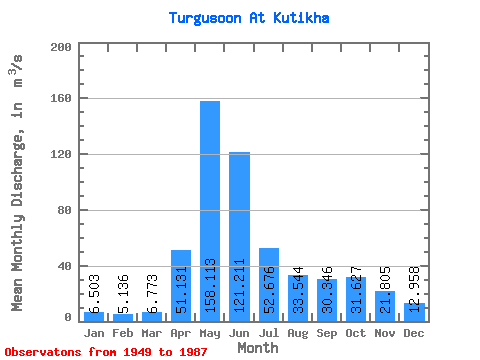
| Units: | mm |
| Statistic | Jan | Feb | Mar | Apr | May | Jun | Jul | Aug | Sep | Oct | Nov | Dec | Annual |
|---|---|---|---|---|---|---|---|---|---|---|---|---|---|
| Mean | 6.50 | 5.14 | 6.77 | 51.13 | 158.11 | 121.21 | 52.68 | 33.54 | 30.35 | 31.63 | 21.80 | 12.96 | 45.30 |
| Standard Deviation | 2.91 | 2.15 | 3.12 | 22.83 | 45.87 | 65.89 | 26.96 | 16.09 | 14.85 | 16.23 | 8.15 | 6.24 | 10.97 |
| Min | 2.23 | 0.84 | 1.02 | 12.50 | 81.90 | 28.60 | 12.40 | 7.45 | 5.76 | 8.72 | 6.86 | 1.84 | 22.08 |
| Max | 16.10 | 12.40 | 13.40 | 112.00 | 277.00 | 269.00 | 150.00 | 87.40 | 65.70 | 69.70 | 41.60 | 28.50 | 70.85 |
| Coefficient of Variation | 0.45 | 0.42 | 0.46 | 0.45 | 0.29 | 0.54 | 0.51 | 0.48 | 0.49 | 0.51 | 0.37 | 0.48 | 0.24 |
 Return to R-Arctic Net Home Page