|
|
|||||||||||||||||
| Point ID: 6980 | Downloads | Plots | Site Data | Code: 11147 |
|
|
|||||||||||||||||
| Download | |
|---|---|
| Site Descriptor Information | Site Time Series Data |
| Link to all available data | |
|
|
| View: | Statistics | Time Series |
| Units: | m3/s |
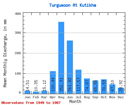
| Statistic | Jan | Feb | Mar | Apr | May | Jun | Jul | Aug | Sep | Oct | Nov | Dec | Annual |
|---|---|---|---|---|---|---|---|---|---|---|---|---|---|
| Mean | 14.51 | 10.44 | 15.12 | 110.44 | 352.86 | 261.81 | 117.56 | 74.86 | 65.55 | 70.58 | 47.10 | 28.92 | 1191.53 |
| Standard Deviation | 6.50 | 4.37 | 6.96 | 49.31 | 102.38 | 142.32 | 60.16 | 35.91 | 32.08 | 36.23 | 17.60 | 13.93 | 288.49 |
| Min | 4.98 | 1.71 | 2.28 | 27.00 | 182.77 | 61.78 | 27.67 | 16.63 | 12.44 | 19.46 | 14.82 | 4.11 | 580.79 |
| Max | 35.93 | 25.21 | 29.90 | 241.92 | 618.17 | 581.04 | 334.75 | 195.05 | 141.91 | 155.55 | 89.86 | 63.60 | 1863.46 |
| Coefficient of Variation | 0.45 | 0.42 | 0.46 | 0.45 | 0.29 | 0.54 | 0.51 | 0.48 | 0.49 | 0.51 | 0.37 | 0.48 | 0.24 |
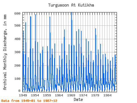
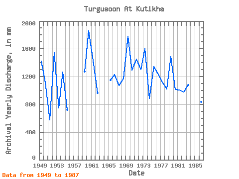
| Year | Jan | Feb | Mar | Apr | May | Jun | Jul | Aug | Sep | Oct | Nov | Dec | Annual | 1949 | 4.98 | 5.92 | 8.79 | 158.11 | 473.11 | 362.88 | 208.88 | 49.77 | 57.67 | 44.41 | 35.64 | 20.22 | 1425.33 | 1950 | 11.81 | 11.83 | 20.93 | 39.96 | 537.83 | 222.48 | 62.93 | 56.02 | 63.29 | 43.07 | 31.54 | 17.81 | 1112.20 | 1951 | 11.56 | 7.93 | 10.96 | 104.54 | 267.80 | 61.78 | 27.67 | 16.63 | 12.44 | 31.02 | 19.94 | 11.76 | 580.79 | 1952 | 8.70 | 5.45 | 5.09 | 80.35 | 584.70 | 563.76 | 151.75 | 53.56 | 31.32 | 34.15 | 21.06 | 13.68 | 1548.94 | 1953 | 11.45 | 5.43 | 7.12 | 82.73 | 336.98 | 135.22 | 55.57 | 33.70 | 20.02 | 30.13 | 19.61 | 12.99 | 746.39 | 1954 | 14.22 | 12.00 | 13.70 | 75.17 | 182.77 | 581.04 | 184.34 | 60.92 | 71.93 | 29.46 | 23.54 | 14.84 | 1266.91 | 1955 | 8.46 | 9.44 | 7.81 | 34.56 | 386.08 | 109.08 | 35.71 | 20.84 | 48.38 | 32.14 | 16.96 | 14.02 | 718.21 | 1956 | 10.53 | 6.79 | 8.15 | 88.99 | 299.04 | 285.12 | 68.29 | 29.01 | 36.07 | 31.69 | 1957 | 10.00 | 27.00 | 296.81 | 339.12 | 97.97 | 154.88 | 38.23 | 41.06 | 38.02 | 27.90 | 1958 | 20.44 | 13.40 | 19.80 | 85.10 | 1959 | 15.51 | 11.77 | 11.36 | 173.88 | 354.83 | 267.84 | 120.29 | 107.79 | 73.44 | 70.74 | 50.76 | 20.55 | 1275.42 | 1960 | 9.95 | 7.83 | 15.27 | 157.68 | 341.44 | 563.76 | 334.75 | 195.05 | 86.40 | 72.75 | 54.43 | 28.79 | 1863.46 | 1961 | 14.28 | 11.39 | 27.67 | 241.92 | 334.75 | 235.44 | 160.23 | 132.12 | 126.36 | 78.33 | 47.09 | 27.90 | 1434.01 | 1962 | 16.56 | 12.24 | 29.90 | 143.21 | 374.92 | 130.68 | 51.33 | 32.58 | 28.08 | 59.14 | 36.72 | 53.11 | 963.33 | 1963 | 10.06 | 9.01 | 18.10 | 75.17 | 186.12 | 161.57 | 76.77 | 73.42 | 58.32 | 62.26 | 51.84 | 1964 | 51.84 | 281.19 | 263.52 | 117.61 | 63.16 | 43.85 | 43.52 | 32.83 | 18.30 | 1965 | 16.63 | 14.40 | 19.37 | 122.69 | 374.92 | 134.57 | 62.04 | 91.94 | 95.04 | 133.45 | 62.64 | 32.58 | 1154.37 | 1966 | 11.05 | 6.28 | 9.78 | 82.51 | 370.46 | 468.72 | 152.87 | 68.51 | 27.43 | 19.46 | 14.82 | 4.11 | 1233.78 | 1967 | 5.16 | 8.66 | 13.01 | 154.22 | 285.65 | 75.82 | 165.81 | 115.38 | 92.02 | 90.83 | 48.17 | 23.21 | 1071.51 | 1968 | 8.10 | 3.11 | 6.20 | 108.00 | 368.23 | 125.71 | 168.94 | 79.00 | 78.19 | 99.76 | 89.86 | 46.87 | 1174.16 | 1969 | 6.61 | 1.71 | 2.28 | 98.50 | 618.17 | 481.68 | 184.11 | 86.14 | 108.00 | 112.25 | 51.84 | 40.39 | 1783.84 | 1970 | 24.32 | 14.74 | 21.07 | 94.82 | 363.76 | 339.12 | 84.80 | 98.19 | 119.02 | 83.24 | 38.02 | 14.35 | 1292.91 | 1971 | 9.98 | 9.60 | 14.28 | 150.55 | 470.88 | 369.36 | 165.81 | 94.62 | 59.62 | 47.31 | 43.63 | 21.67 | 1452.42 | 1972 | 19.95 | 15.47 | 20.38 | 137.59 | 486.50 | 250.56 | 130.11 | 64.94 | 54.86 | 49.99 | 56.59 | 18.68 | 1299.99 | 1973 | 6.49 | 7.93 | 7.59 | 216.00 | 473.11 | 414.72 | 170.72 | 112.48 | 63.72 | 60.48 | 46.44 | 28.57 | 1604.32 | 1974 | 13.75 | 11.43 | 18.46 | 164.59 | 281.19 | 98.71 | 53.34 | 41.73 | 65.02 | 52.22 | 52.70 | 35.04 | 885.76 | 1975 | 17.68 | 12.00 | 23.66 | 83.59 | 299.04 | 399.60 | 114.26 | 70.97 | 99.58 | 126.54 | 76.68 | 26.11 | 1348.14 | 1976 | 9.78 | 10.39 | 15.96 | 93.31 | 392.77 | 178.63 | 100.20 | 66.06 | 138.46 | 144.84 | 55.08 | 42.85 | 1242.11 | 1977 | 24.32 | 14.01 | 29.23 | 142.13 | 316.90 | 172.58 | 94.85 | 104.22 | 39.10 | 108.01 | 49.46 | 32.14 | 1121.23 | 1978 | 22.23 | 10.49 | 18.19 | 201.74 | 245.48 | 214.70 | 85.03 | 62.71 | 35.42 | 56.02 | 47.95 | 21.85 | 1020.79 | 1979 | 16.38 | 8.95 | 12.10 | 85.97 | 493.20 | 378.00 | 180.54 | 67.40 | 60.48 | 94.40 | 65.88 | 33.03 | 1489.59 | 1980 | 14.64 | 6.83 | 7.50 | 77.11 | 328.06 | 259.20 | 120.29 | 57.13 | 42.55 | 39.95 | 37.58 | 31.47 | 1018.20 | 1981 | 24.55 | 12.83 | 21.62 | 148.82 | 372.69 | 130.90 | 74.09 | 57.13 | 54.43 | 59.36 | 42.77 | 15.02 | 1009.55 | 1982 | 12.05 | 8.19 | 8.30 | 124.42 | 290.12 | 120.10 | 60.03 | 56.24 | 56.59 | 144.17 | 65.02 | 41.73 | 981.98 | 1983 | 21.36 | 9.96 | 21.89 | 90.50 | 294.58 | 235.44 | 87.48 | 60.03 | 78.62 | 73.20 | 66.53 | 44.41 | 1080.89 | 1984 | 35.93 | 25.21 | 20.91 | 55.30 | 252.18 | 181.22 | 101.76 | 81.46 | 55.51 | 77.22 | 64.37 | 48.43 | 995.61 | 1985 | 16.63 | 19.68 | 20.84 | 95.90 | 236.56 | 233.28 | 123.63 | 90.61 | 86.18 | 87.03 | 69.12 | 48.87 | 1125.79 | 1986 | 13.50 | 12.63 | 15.02 | 72.36 | 267.80 | 133.06 | 71.41 | 53.78 | 43.20 | 62.93 | 50.33 | 44.19 | 836.10 | 1987 | 17.36 | 11.51 | 12.10 | 86.40 | 287.88 | 270.00 | 160.90 | 84.58 | 141.91 | 155.55 | 67.18 | 63.60 | 1354.14 |
|---|
 Return to R-Arctic Net Home Page