|
|
|||||||||||||||||
| Point ID: 6977 | Downloads | Plots | Site Data | Code: 11143 |
|
|
|||||||||||||||||
| Download | |
|---|---|
| Site Descriptor Information | Site Time Series Data |
| Link to all available data | |
| View: | Time Series | All |
| Units: | m3/s |
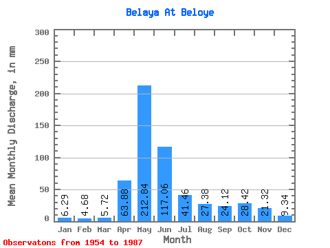
| Statistic | Jan | Feb | Mar | Apr | May | Jun | Jul | Aug | Sep | Oct | Nov | Dec | Annual |
|---|---|---|---|---|---|---|---|---|---|---|---|---|---|
| Mean | 6.29 | 4.72 | 5.72 | 63.88 | 212.81 | 117.06 | 41.45 | 27.37 | 24.12 | 28.41 | 21.32 | 9.34 | 560.24 |
| Standard Deviation | 1.50 | 1.35 | 2.58 | 26.39 | 59.27 | 79.31 | 28.66 | 18.48 | 16.29 | 17.62 | 23.76 | 3.10 | 162.65 |
| Min | 4.14 | 2.71 | 2.38 | 19.04 | 106.27 | 20.93 | 9.27 | 7.08 | 9.35 | 10.20 | 7.02 | 4.99 | 295.73 |
| Max | 9.38 | 8.96 | 17.03 | 121.78 | 320.23 | 304.46 | 135.46 | 90.68 | 84.48 | 91.53 | 146.47 | 18.00 | 851.23 |
| Coefficient of Variation | 0.24 | 0.29 | 0.45 | 0.41 | 0.28 | 0.68 | 0.69 | 0.68 | 0.68 | 0.62 | 1.11 | 0.33 | 0.29 |
 Return to R-Arctic Net Home Page