|
|
|||||||||||||||||
| Point ID: 6977 | Downloads | Plots | Site Data | Code: 11143 |
|
|
|||||||||||||||||
| Download | |
|---|---|
| Site Descriptor Information | Site Time Series Data |
| Link to all available data | |
|
|
| View: | Statistics | Time Series |
| Units: | m3/s |
| Statistic | Jan | Feb | Mar | Apr | May | Jun | Jul | Aug | Sep | Oct | Nov | Dec | Annual |
|---|---|---|---|---|---|---|---|---|---|---|---|---|---|
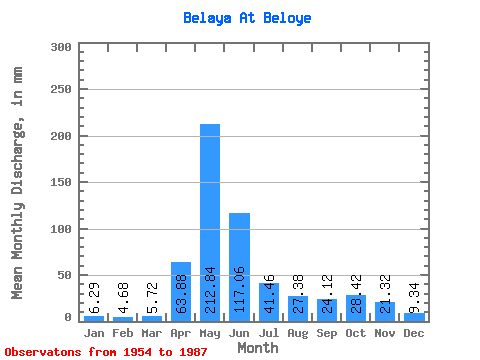
| Mean | 6.29 | 4.72 | 5.72 | 63.88 | 212.81 | 117.06 | 41.45 | 27.37 | 24.12 | 28.41 | 21.32 | 9.34 | 560.24 |
| Standard Deviation | 1.50 | 1.35 | 2.58 | 26.39 | 59.27 | 79.31 | 28.66 | 18.48 | 16.29 | 17.62 | 23.76 | 3.10 | 162.65 |
| Min | 4.14 | 2.71 | 2.38 | 19.04 | 106.27 | 20.93 | 9.27 | 7.08 | 9.35 | 10.20 | 7.02 | 4.99 | 295.73 |
| Max | 9.38 | 8.96 | 17.03 | 121.78 | 320.23 | 304.46 | 135.46 | 90.68 | 84.48 | 91.53 | 146.47 | 18.00 | 851.23 |
| Coefficient of Variation | 0.24 | 0.29 | 0.45 | 0.41 | 0.28 | 0.68 | 0.69 | 0.68 | 0.68 | 0.62 | 1.11 | 0.33 | 0.29 |
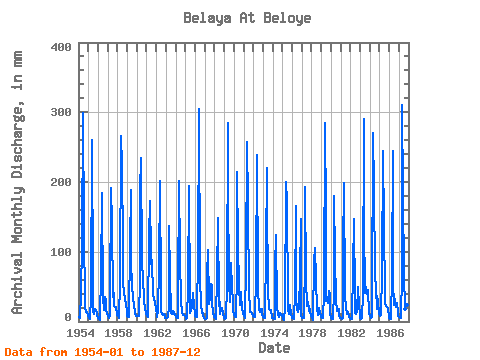
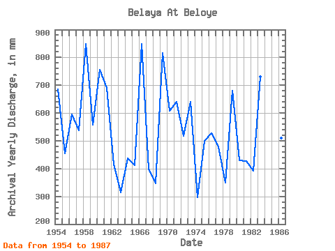
| Year | Jan | Feb | Mar | Apr | May | Jun | Jul | Aug | Sep | Oct | Nov | Dec | Annual | 1954 | 6.52 | 5.32 | 5.53 | 39.22 | 115.34 | 298.97 | 135.46 | 24.54 | 19.45 | 14.71 | 13.30 | 7.79 | 686.44 | 1955 | 5.78 | 4.54 | 3.91 | 37.03 | 268.65 | 60.34 | 15.36 | 11.31 | 18.05 | 16.38 | 10.39 | 7.79 | 455.84 | 1956 | 5.67 | 2.89 | 2.55 | 71.04 | 184.48 | 184.59 | 34.29 | 17.17 | 35.38 | 30.04 | 17.91 | 10.40 | 596.08 | 1957 | 7.71 | 5.11 | 8.16 | 30.72 | 197.52 | 139.34 | 36.56 | 41.66 | 22.16 | 20.89 | 20.65 | 9.12 | 537.36 | 1958 | 8.33 | 4.23 | 4.82 | 57.05 | 274.32 | 223.54 | 112.22 | 51.86 | 44.98 | 30.89 | 27.15 | 14.25 | 850.25 | 1959 | 8.02 | 6.74 | 6.58 | 109.71 | 194.12 | 86.95 | 50.44 | 38.26 | 21.50 | 16.86 | 12.37 | 8.73 | 558.39 | 1960 | 7.57 | 7.41 | 8.36 | 60.34 | 193.84 | 234.79 | 87.57 | 63.48 | 32.09 | 28.62 | 20.87 | 11.70 | 755.13 | 1961 | 8.47 | 6.64 | 6.97 | 121.78 | 178.25 | 97.65 | 66.31 | 90.68 | 37.85 | 34.01 | 26.82 | 18.00 | 690.90 | 1962 | 8.93 | 6.02 | 17.03 | 77.90 | 208.86 | 37.30 | 15.16 | 10.91 | 9.63 | 11.59 | 8.12 | 5.81 | 414.68 | 1963 | 4.76 | 4.88 | 7.31 | 21.81 | 140.84 | 66.93 | 13.12 | 10.91 | 10.72 | 15.25 | 11.63 | 8.98 | 315.54 | 1964 | 6.38 | 4.57 | 4.93 | 39.50 | 208.29 | 92.98 | 26.95 | 17.43 | 11.82 | 10.20 | 9.27 | 7.42 | 437.30 | 1965 | 4.62 | 3.72 | 5.27 | 47.45 | 200.35 | 28.25 | 13.15 | 15.53 | 22.30 | 41.94 | 22.25 | 10.54 | 412.20 | 1966 | 8.59 | 5.47 | 6.75 | 101.76 | 297.56 | 304.46 | 62.91 | 24.54 | 12.64 | 12.02 | 8.45 | 5.75 | 850.09 | 1967 | 4.14 | 3.18 | 4.59 | 66.93 | 106.27 | 24.77 | 35.42 | 55.83 | 51.02 | 28.03 | 13.33 | 6.69 | 398.40 | 1968 | 4.99 | 3.54 | 5.30 | 65.28 | 153.31 | 22.27 | 28.91 | 11.08 | 16.73 | 19.47 | 11.03 | 7.17 | 346.91 | 1969 | 5.92 | 4.00 | 5.27 | 51.57 | 294.72 | 190.63 | 59.79 | 29.19 | 84.48 | 48.74 | 29.07 | 15.50 | 816.19 | 1970 | 9.38 | 5.58 | 6.66 | 70.77 | 221.61 | 107.79 | 52.71 | 24.32 | 42.24 | 35.99 | 21.39 | 11.19 | 607.13 | 1971 | 7.42 | 4.78 | 6.06 | 81.74 | 265.25 | 168.14 | 39.67 | 21.59 | 13.52 | 13.63 | 12.29 | 8.76 | 640.77 | 1972 | 6.97 | 6.07 | 6.92 | 65.55 | 247.11 | 61.99 | 49.03 | 17.00 | 13.69 | 18.73 | 17.91 | 10.82 | 518.21 | 1973 | 6.32 | 5.40 | 5.50 | 103.41 | 227.28 | 174.72 | 46.48 | 19.10 | 15.94 | 15.64 | 16.24 | 5.61 | 640.75 | 1974 | 4.59 | 3.90 | 4.22 | 78.45 | 128.09 | 20.93 | 9.27 | 7.08 | 9.65 | 12.44 | 8.70 | 9.52 | 295.73 | 1975 | 4.39 | 2.71 | 2.38 | 19.04 | 207.16 | 173.07 | 25.39 | 16.44 | 10.75 | 25.11 | 10.92 | 5.81 | 501.37 | 1976 | 4.45 | 4.21 | 3.71 | 41.14 | 170.88 | 33.19 | 16.92 | 13.77 | 20.41 | 66.31 | 146.47 | 8.08 | 528.31 | 1977 | 4.76 | 4.34 | 5.33 | 91.89 | 199.22 | 61.44 | 23.44 | 28.20 | 15.20 | 23.01 | 13.44 | 8.33 | 476.35 | 1978 | 5.33 | 3.90 | 2.58 | 87.22 | 108.25 | 60.07 | 17.60 | 17.91 | 9.35 | 19.95 | 11.57 | 7.34 | 350.64 | 1979 | 5.16 | 4.88 | 4.51 | 40.59 | 294.72 | 153.87 | 30.32 | 30.04 | 25.92 | 45.91 | 37.30 | 10.43 | 680.26 | 1980 | 5.21 | 3.31 | 3.63 | 43.06 | 186.47 | 92.98 | 32.31 | 15.62 | 16.29 | 19.04 | 9.77 | 5.30 | 430.82 | 1981 | 5.24 | 3.77 | 4.96 | 101.76 | 205.17 | 39.50 | 18.87 | 12.30 | 10.67 | 14.34 | 7.02 | 4.99 | 426.45 | 1982 | 4.99 | 4.03 | 4.05 | 74.61 | 151.33 | 32.91 | 13.04 | 11.73 | 12.95 | 51.58 | 22.16 | 11.62 | 392.94 | 1983 | 5.87 | 4.03 | 5.44 | 40.05 | 300.39 | 142.63 | 41.94 | 51.29 | 39.77 | 47.04 | 44.71 | 12.50 | 731.56 | 1984 | 7.71 | 4.75 | 6.26 | 26.69 | 279.70 | 190.90 | 66.88 | 49.03 | 17.42 | 38.26 | 28.25 | 11.56 | 723.40 | 1985 | 7.65 | 8.96 | 9.44 | 69.67 | 252.78 | 136.32 | 39.39 | 27.63 | 22.82 | 21.00 | 17.64 | 8.02 | 619.07 | 1986 | 5.64 | 3.10 | 4.39 | 67.75 | 253.06 | 54.58 | 24.29 | 34.01 | 20.49 | 26.92 | 13.41 | 7.51 | 511.31 | 1987 | 6.21 | 4.54 | 5.21 | 69.39 | 320.23 | 181.30 | 68.30 | 19.21 | 52.11 | 91.53 | 23.09 | 14.37 | 851.23 |
|---|
 Return to R-Arctic Net Home Page