|
|
|||||||||||||||||
| Point ID: 6977 | Downloads | Plots | Site Data | Code: 11143 |
|
|
|||||||||||||||||
| Download | |
|---|---|
| Site Descriptor Information | Site Time Series Data |
| Link to all available data | |
| View: | Time Series | All |
| Units: | mm |
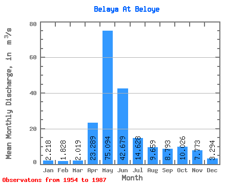
| Statistic | Jan | Feb | Mar | Apr | May | Jun | Jul | Aug | Sep | Oct | Nov | Dec | Annual |
|---|---|---|---|---|---|---|---|---|---|---|---|---|---|
| Mean | 2.22 | 1.83 | 2.02 | 23.29 | 75.09 | 42.68 | 14.63 | 9.66 | 8.79 | 10.03 | 7.77 | 3.29 | 16.77 |
| Standard Deviation | 0.53 | 0.52 | 0.91 | 9.62 | 20.92 | 28.91 | 10.12 | 6.52 | 5.94 | 6.22 | 8.66 | 1.09 | 4.87 |
| Min | 1.46 | 1.05 | 0.84 | 6.94 | 37.50 | 7.63 | 3.27 | 2.50 | 3.41 | 3.60 | 2.56 | 1.76 | 8.86 |
| Max | 3.31 | 3.47 | 6.01 | 44.40 | 113.00 | 111.00 | 47.80 | 32.00 | 30.80 | 32.30 | 53.40 | 6.35 | 25.49 |
| Coefficient of Variation | 0.24 | 0.29 | 0.45 | 0.41 | 0.28 | 0.68 | 0.69 | 0.68 | 0.68 | 0.62 | 1.11 | 0.33 | 0.29 |
 Return to R-Arctic Net Home Page