|
|
|||||||||||||||||
| Point ID: 6817 | Downloads | Plots | Site Data | Other Close Sites | Code: 10388 |
|
|
|||||||||||||||||
| Download | |
|---|---|
| Site Descriptor Information | Site Time Series Data |
| Link to all available data | |
| View: | Time Series | All |
| Units: | m3/s |
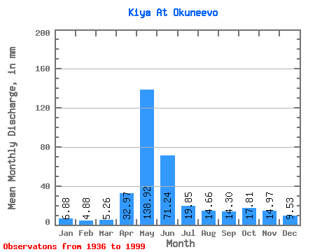
| Statistic | Jan | Feb | Mar | Apr | May | Jun | Jul | Aug | Sep | Oct | Nov | Dec | Annual |
|---|---|---|---|---|---|---|---|---|---|---|---|---|---|
| Mean | 6.88 | 4.92 | 5.26 | 32.97 | 138.90 | 71.24 | 19.85 | 14.66 | 14.30 | 17.81 | 14.97 | 9.53 | 353.22 |
| Standard Deviation | 2.38 | 1.25 | 1.50 | 17.76 | 27.92 | 35.37 | 7.78 | 5.95 | 6.28 | 7.33 | 6.49 | 3.55 | 61.27 |
| Min | 4.24 | 2.36 | 1.75 | 5.60 | 75.13 | 14.79 | 7.28 | 4.87 | 4.02 | 2.88 | 6.07 | 5.55 | 259.03 |
| Max | 15.31 | 8.45 | 10.37 | 87.15 | 201.30 | 149.78 | 41.88 | 33.97 | 31.31 | 31.45 | 30.44 | 22.65 | 523.67 |
| Coefficient of Variation | 0.34 | 0.25 | 0.28 | 0.54 | 0.20 | 0.50 | 0.39 | 0.41 | 0.44 | 0.41 | 0.43 | 0.37 | 0.17 |
| Other Close Sites | ||||||
|---|---|---|---|---|---|---|
| PointID | Latitude | Longitude | Drainage Area | Source | Name | |
| 6792 | "Chulym At Zyryanskoye" | 56.85 | -214315 | SHI | 373.00 | |
 Return to R-Arctic Net Home Page