|
|
|||||||||||||||||
| Point ID: 6817 | Downloads | Plots | Site Data | Other Close Sites | Code: 10388 |
|
|
|||||||||||||||||
| Download | |
|---|---|
| Site Descriptor Information | Site Time Series Data |
| Link to all available data | |
|
|
| View: | Statistics | Time Series |
| Units: | m3/s |
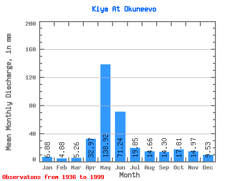
| Statistic | Jan | Feb | Mar | Apr | May | Jun | Jul | Aug | Sep | Oct | Nov | Dec | Annual |
|---|---|---|---|---|---|---|---|---|---|---|---|---|---|
| Mean | 6.88 | 4.92 | 5.26 | 32.97 | 138.90 | 71.24 | 19.85 | 14.66 | 14.30 | 17.81 | 14.97 | 9.53 | 353.22 |
| Standard Deviation | 2.38 | 1.25 | 1.50 | 17.76 | 27.92 | 35.37 | 7.78 | 5.95 | 6.28 | 7.33 | 6.49 | 3.55 | 61.27 |
| Min | 4.24 | 2.36 | 1.75 | 5.60 | 75.13 | 14.79 | 7.28 | 4.87 | 4.02 | 2.88 | 6.07 | 5.55 | 259.03 |
| Max | 15.31 | 8.45 | 10.37 | 87.15 | 201.30 | 149.78 | 41.88 | 33.97 | 31.31 | 31.45 | 30.44 | 22.65 | 523.67 |
| Coefficient of Variation | 0.34 | 0.25 | 0.28 | 0.54 | 0.20 | 0.50 | 0.39 | 0.41 | 0.44 | 0.41 | 0.43 | 0.37 | 0.17 |
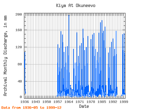
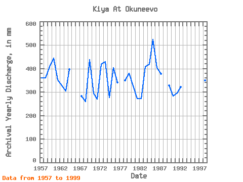
| Year | Jan | Feb | Mar | Apr | May | Jun | Jul | Aug | Sep | Oct | Nov | Dec | Annual | 1936 | 75.13 | 108.20 | 22.47 | 20.85 | 19.31 | 13.28 | 1957 | 5.25 | 4.50 | 4.73 | 39.84 | 129.77 | 83.15 | 26.96 | 15.01 | 16.47 | 13.75 | 13.79 | 8.45 | 360.61 | 1958 | 6.47 | 5.24 | 5.64 | 27.31 | 121.14 | 104.20 | 21.39 | 19.59 | 12.39 | 17.85 | 12.75 | 8.05 | 361.14 | 1959 | 6.76 | 4.60 | 5.14 | 21.22 | 161.94 | 108.55 | 30.91 | 17.60 | 16.63 | 16.03 | 11.65 | 8.41 | 407.70 | 1960 | 5.57 | 4.19 | 4.58 | 26.27 | 153.49 | 112.90 | 41.34 | 25.16 | 31.31 | 20.13 | 13.88 | 7.80 | 445.04 | 1961 | 6.60 | 5.65 | 6.17 | 87.15 | 111.79 | 37.40 | 20.85 | 15.74 | 17.74 | 21.93 | 12.51 | 8.70 | 351.50 | 1962 | 5.84 | 4.41 | 6.31 | 45.92 | 123.83 | 45.92 | 30.38 | 18.69 | 9.53 | 19.77 | 11.71 | 7.21 | 327.73 | 1963 | 7.17 | 5.60 | 5.61 | 11.55 | 125.45 | 54.10 | 11.54 | 11.14 | 18.79 | 21.39 | 16.51 | 16.30 | 303.51 | 1964 | 15.31 | 6.89 | 5.34 | 5.60 | 201.30 | 98.81 | 21.75 | 11.90 | 8.25 | 8.23 | 8.21 | 8.03 | 397.06 | 1965 | 5.95 | 4.22 | 4.66 | 29.92 | 11.61 | 7.41 | 24.18 | 18.15 | 12.42 | 12.71 | 1966 | 9.01 | 4.49 | 4.19 | 20.49 | 11.65 | 6.73 | 8.29 | 8.02 | 7.33 | 1967 | 4.94 | 3.82 | 4.33 | 36.36 | 118.80 | 24.01 | 22.11 | 15.40 | 18.44 | 17.56 | 12.07 | 6.06 | 282.13 | 1968 | 4.67 | 3.65 | 7.41 | 29.57 | 85.73 | 21.92 | 15.08 | 33.97 | 18.09 | 15.24 | 16.49 | 8.72 | 259.03 | 1969 | 6.40 | 4.13 | 4.64 | 13.69 | 159.06 | 149.78 | 22.83 | 14.74 | 13.83 | 19.59 | 19.48 | 10.66 | 437.76 | 1970 | 4.24 | 3.23 | 2.93 | 52.01 | 101.55 | 64.02 | 17.04 | 15.35 | 7.81 | 10.19 | 8.84 | 6.25 | 292.83 | 1971 | 5.00 | 3.57 | 3.38 | 41.92 | 127.25 | 39.49 | 20.67 | 6.83 | 5.53 | 4.89 | 6.07 | 6.56 | 269.67 | 1972 | 4.31 | 3.69 | 3.92 | 39.49 | 133.00 | 94.63 | 41.88 | 22.11 | 26.44 | 21.57 | 18.27 | 10.82 | 418.77 | 1973 | 6.88 | 6.32 | 6.65 | 54.10 | 167.69 | 120.03 | 26.06 | 16.39 | 5.29 | 6.17 | 6.96 | 7.08 | 428.60 | 1974 | 4.40 | 2.36 | 1.75 | 40.53 | 115.93 | 39.31 | 12.33 | 7.94 | 10.28 | 26.78 | 10.87 | 5.55 | 276.58 | 1975 | 4.46 | 4.42 | 5.50 | 28.01 | 122.58 | 119.34 | 20.85 | 11.11 | 19.14 | 26.06 | 28.18 | 13.28 | 402.46 | 1976 | 8.03 | 4.76 | 4.80 | 17.74 | 149.72 | 45.92 | 16.36 | 16.16 | 19.48 | 30.20 | 19.83 | 9.71 | 340.38 | 1977 | 6.33 | 3.75 | 4.35 | 10.10 | 9.47 | 15.06 | 11.29 | 10.40 | 7.13 | 1978 | 5.30 | 4.54 | 5.10 | 32.88 | 142.89 | 59.15 | 20.31 | 18.69 | 16.84 | 2.88 | 25.75 | 17.65 | 350.48 | 1979 | 11.68 | 5.08 | 5.86 | 13.48 | 153.85 | 92.55 | 15.82 | 12.80 | 16.82 | 23.36 | 20.53 | 9.72 | 379.87 | 1980 | 6.63 | 4.41 | 4.35 | 29.40 | 157.09 | 44.53 | 19.23 | 16.62 | 9.46 | 9.33 | 12.99 | 13.34 | 325.08 | 1981 | 7.19 | 5.63 | 6.24 | 52.71 | 118.98 | 24.88 | 9.04 | 8.91 | 8.11 | 16.36 | 8.11 | 6.49 | 271.35 | 1982 | 5.28 | 3.98 | 4.62 | 69.41 | 111.61 | 14.79 | 7.28 | 4.87 | 4.02 | 22.47 | 14.86 | 9.29 | 271.33 | 1983 | 7.04 | 6.83 | 6.83 | 13.41 | 157.80 | 96.20 | 19.05 | 9.27 | 9.60 | 29.84 | 30.44 | 22.65 | 407.17 | 1984 | 12.99 | 8.45 | 10.37 | 13.83 | 183.33 | 102.98 | 26.24 | 10.51 | 8.52 | 15.38 | 18.96 | 9.13 | 418.68 | 1985 | 5.80 | 3.98 | 3.29 | 53.41 | 188.72 | 122.29 | 31.45 | 29.84 | 22.27 | 25.70 | 30.09 | 8.43 | 523.67 | 1986 | 7.78 | 6.32 | 5.73 | 28.53 | 162.30 | 112.90 | 18.51 | 14.77 | 15.13 | 16.97 | 9.93 | 5.59 | 403.25 | 1987 | 4.28 | 4.22 | 3.40 | 17.29 | 172.72 | 67.32 | 21.39 | 16.10 | 22.79 | 30.38 | 10.51 | 8.79 | 376.64 | 1989 | 9.29 | 7.01 | 7.24 | 53.06 | 110.17 | 81.41 | 13.82 | 7.75 | 4.37 | 6.79 | 18.79 | 8.45 | 328.08 | 1990 | 7.44 | 5.62 | 5.39 | 25.75 | 122.22 | 28.18 | 13.93 | 15.01 | 12.46 | 31.45 | 10.23 | 7.94 | 283.53 | 1991 | 7.32 | 5.55 | 5.18 | 25.92 | 135.70 | 30.79 | 13.75 | 12.11 | 13.55 | 18.33 | 17.40 | 13.21 | 296.84 | 1992 | 8.45 | 4.93 | 5.23 | 19.14 | 143.78 | 57.06 | 13.93 | 13.59 | 15.69 | 16.36 | 12.49 | 12.47 | 321.19 | 1993 | 8.82 | 5.65 | 4.73 | 33.40 | 119.16 | 84.37 | 23.18 | 16.14 | 17.57 | 22.47 | 8.18 | 5.75 | 348.38 | 1994 | 4.75 | 3.93 | 6.02 | 46.62 | 162.66 | 48.53 | 14.29 | 13.14 | 12.80 | 21.39 | 25.92 | 9.85 | 368.01 | 1998 | 6.88 | 5.40 | 6.06 | 14.09 | 154.75 | 75.85 | 14.67 | 10.80 | 10.23 | 21.75 | 20.35 | 10.60 | 349.58 | 1999 | 7.85 | 7.06 | 7.44 | 26.44 | 156.55 | 61.76 | 13.05 | 11.12 | 10.99 | 12.74 | 9.46 | 7.58 | 330.32 |
|---|
| Other Close Sites | ||||||
|---|---|---|---|---|---|---|
| PointID | Latitude | Longitude | Drainage Area | Source | Name | |
| 6792 | "Chulym At Zyryanskoye" | 56.85 | -214315 | SHI | 373.00 | |
 Return to R-Arctic Net Home Page