|
|
|||||||||||||||||
| Point ID: 6792 | Downloads | Plots | Site Data | Other Close Sites | Code: 10329 |
|
|
|||||||||||||||||
| Download | |
|---|---|
| Site Descriptor Information | Site Time Series Data |
| Link to all available data | |
| View: | Time Series | All |
| Units: | m3/s |
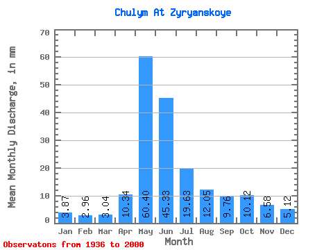
| Statistic | Jan | Feb | Mar | Apr | May | Jun | Jul | Aug | Sep | Oct | Nov | Dec | Annual |
|---|---|---|---|---|---|---|---|---|---|---|---|---|---|
| Mean | 3.87 | 2.98 | 3.04 | 10.34 | 60.39 | 45.33 | 19.62 | 12.04 | 9.76 | 10.12 | 6.58 | 5.12 | 188.31 |
| Standard Deviation | 1.03 | 0.76 | 0.68 | 6.75 | 13.00 | 15.70 | 6.30 | 4.13 | 2.88 | 3.21 | 2.23 | 1.82 | 32.99 |
| Min | 1.84 | 1.70 | 1.92 | 3.08 | 19.40 | 12.22 | 8.22 | 5.30 | 4.54 | 4.63 | 2.77 | 2.44 | 97.84 |
| Max | 6.86 | 5.54 | 4.60 | 37.83 | 87.14 | 82.66 | 33.29 | 29.53 | 16.98 | 19.02 | 15.10 | 13.43 | 253.87 |
| Coefficient of Variation | 0.27 | 0.26 | 0.23 | 0.65 | 0.21 | 0.35 | 0.32 | 0.34 | 0.29 | 0.32 | 0.34 | 0.35 | 0.17 |
| Other Close Sites | ||||||
|---|---|---|---|---|---|---|
| PointID | Latitude | Longitude | Drainage Area | Source | Name | |
| 6817 | "Kiya At Okuneevo" | 56.77 | -192595 | SHI | 34.00 | |
 Return to R-Arctic Net Home Page