|
|
|||||||||||||||||
| Point ID: 6792 | Downloads | Plots | Site Data | Other Close Sites | Code: 10329 |
|
|
|||||||||||||||||
| Download | |
|---|---|
| Site Descriptor Information | Site Time Series Data |
| Link to all available data | |
| View: | Time Series | All |
| Units: | mm |
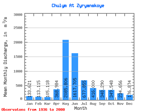
| Statistic | Jan | Feb | Mar | Apr | May | Jun | Jul | Aug | Sep | Oct | Nov | Dec | Annual |
|---|---|---|---|---|---|---|---|---|---|---|---|---|---|
| Mean | 133.62 | 113.11 | 105.12 | 368.98 | 2085.81 | 1617.70 | 677.86 | 416.00 | 348.29 | 349.55 | 234.66 | 176.87 | 551.92 |
| Standard Deviation | 35.58 | 28.89 | 23.63 | 241.05 | 448.95 | 560.11 | 217.50 | 142.70 | 102.72 | 110.96 | 79.68 | 62.72 | 96.68 |
| Min | 63.70 | 64.50 | 66.30 | 110.00 | 670.00 | 436.00 | 284.00 | 183.00 | 162.00 | 160.00 | 98.70 | 84.30 | 286.76 |
| Max | 237.00 | 210.00 | 159.00 | 1350.00 | 3010.00 | 2950.00 | 1150.00 | 1020.00 | 606.00 | 657.00 | 539.00 | 464.00 | 744.08 |
| Coefficient of Variation | 0.27 | 0.26 | 0.23 | 0.65 | 0.21 | 0.35 | 0.32 | 0.34 | 0.29 | 0.32 | 0.34 | 0.35 | 0.17 |
| Other Close Sites | ||||||
|---|---|---|---|---|---|---|
| PointID | Latitude | Longitude | Drainage Area | Source | Name | |
| 6817 | "Kiya At Okuneevo" | 56.77 | -192595 | SHI | 34.00 | |
 Return to R-Arctic Net Home Page