|
|
|||||||||||||||||
| Point ID: 6774 | Downloads | Plots | Site Data | Code: 10281 |
|
|
|||||||||||||||||
| Download | |
|---|---|
| Site Descriptor Information | Site Time Series Data |
| Link to all available data | |
| View: | Time Series | All |
| Units: | m3/s |
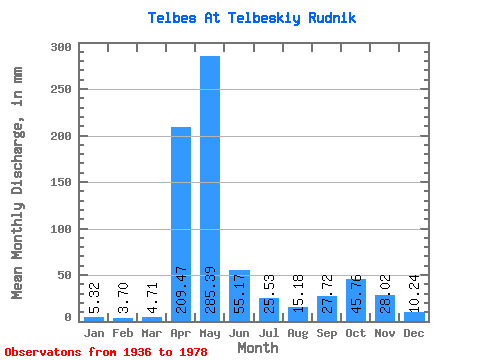
| Statistic | Jan | Feb | Mar | Apr | May | Jun | Jul | Aug | Sep | Oct | Nov | Dec | Annual |
|---|---|---|---|---|---|---|---|---|---|---|---|---|---|
| Mean | 5.32 | 3.73 | 4.71 | 209.47 | 285.35 | 55.17 | 25.53 | 15.18 | 27.72 | 45.75 | 28.02 | 10.23 | 714.15 |
| Standard Deviation | 2.72 | 1.64 | 2.57 | 88.56 | 143.50 | 45.62 | 28.39 | 11.23 | 26.20 | 35.75 | 26.03 | 6.88 | 154.48 |
| Min | 2.03 | 1.19 | 2.34 | 19.17 | 100.12 | 4.83 | 3.02 | 3.09 | 2.29 | 5.36 | 4.44 | 2.48 | 453.95 |
| Max | 14.48 | 9.41 | 14.60 | 401.64 | 632.11 | 193.58 | 122.08 | 64.66 | 120.73 | 147.65 | 127.50 | 31.36 | 1078.65 |
| Coefficient of Variation | 0.51 | 0.44 | 0.55 | 0.42 | 0.50 | 0.83 | 1.11 | 0.74 | 0.94 | 0.78 | 0.93 | 0.67 | 0.22 |
 Return to R-Arctic Net Home Page