|
|
|||||||||||||||||
| Point ID: 6774 | Downloads | Plots | Site Data | Code: 10281 |
|
|
|||||||||||||||||
| Download | |
|---|---|
| Site Descriptor Information | Site Time Series Data |
| Link to all available data | |
|
|
| View: | Statistics | Time Series |
| Units: | m3/s |
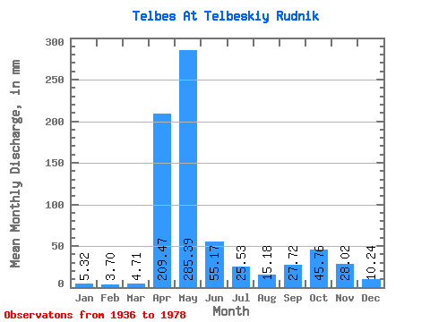
| Statistic | Jan | Feb | Mar | Apr | May | Jun | Jul | Aug | Sep | Oct | Nov | Dec | Annual |
|---|---|---|---|---|---|---|---|---|---|---|---|---|---|
| Mean | 5.32 | 3.73 | 4.71 | 209.47 | 285.35 | 55.17 | 25.53 | 15.18 | 27.72 | 45.75 | 28.02 | 10.23 | 714.15 |
| Standard Deviation | 2.72 | 1.64 | 2.57 | 88.56 | 143.50 | 45.62 | 28.39 | 11.23 | 26.20 | 35.75 | 26.03 | 6.88 | 154.48 |
| Min | 2.03 | 1.19 | 2.34 | 19.17 | 100.12 | 4.83 | 3.02 | 3.09 | 2.29 | 5.36 | 4.44 | 2.48 | 453.95 |
| Max | 14.48 | 9.41 | 14.60 | 401.64 | 632.11 | 193.58 | 122.08 | 64.66 | 120.73 | 147.65 | 127.50 | 31.36 | 1078.65 |
| Coefficient of Variation | 0.51 | 0.44 | 0.55 | 0.42 | 0.50 | 0.83 | 1.11 | 0.74 | 0.94 | 0.78 | 0.93 | 0.67 | 0.22 |
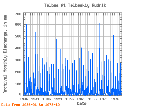
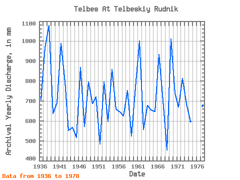
| Year | Jan | Feb | Mar | Apr | May | Jun | Jul | Aug | Sep | Oct | Nov | Dec | Annual | 1936 | 2.68 | 2.59 | 2.39 | 26.15 | 446.33 | 139.17 | 3.59 | 12.59 | 31.76 | 7.17 | 24.75 | 14.64 | 708.51 | 1937 | 7.74 | 6.99 | 3.19 | 19.17 | 617.63 | 123.53 | 26.78 | 3.19 | 44.84 | 45.12 | 65.62 | 15.08 | 970.23 | 1938 | 4.63 | 2.75 | 6.01 | 324.58 | 267.80 | 71.92 | 122.08 | 24.61 | 81.96 | 145.72 | 19.92 | 9.55 | 1078.65 | 1939 | 4.39 | 3.12 | 3.31 | 312.91 | 150.55 | 81.96 | 27.50 | 5.33 | 11.98 | 21.13 | 7.57 | 5.60 | 637.76 | 1940 | 6.47 | 3.83 | 4.46 | 261.54 | 124.73 | 22.84 | 12.30 | 10.52 | 7.64 | 147.65 | 59.55 | 29.68 | 690.62 | 1941 | 10.28 | 5.25 | 7.41 | 157.62 | 550.08 | 94.57 | 94.33 | 9.55 | 11.35 | 27.26 | 20.97 | 7.94 | 988.52 | 1942 | 3.50 | 3.21 | 4.32 | 133.34 | 359.48 | 55.58 | 35.95 | 31.61 | 10.18 | 93.61 | 53.94 | 16.96 | 795.85 | 1943 | 2.90 | 2.42 | 3.33 | 249.86 | 131.73 | 10.84 | 11.46 | 3.09 | 3.81 | 43.43 | 60.71 | 26.54 | 551.07 | 1944 | 4.97 | 3.30 | 8.73 | 315.24 | 138.24 | 9.36 | 19.16 | 7.58 | 15.04 | 29.68 | 9.57 | 5.33 | 567.75 | 1945 | 2.65 | 2.18 | 3.19 | 259.20 | 138.00 | 4.83 | 41.01 | 7.33 | 2.90 | 22.17 | 24.29 | 8.40 | 516.59 | 1946 | 3.09 | 4.07 | 4.25 | 233.51 | 330.53 | 91.77 | 5.72 | 4.85 | 120.73 | 43.91 | 16.70 | 10.11 | 869.11 | 1947 | 4.95 | 3.71 | 4.58 | 238.18 | 131.00 | 47.40 | 39.08 | 64.66 | 21.65 | 5.57 | 6.07 | 5.28 | 572.46 | 1948 | 4.73 | 3.65 | 6.66 | 235.85 | 270.21 | 68.65 | 47.77 | 12.93 | 50.67 | 69.24 | 16.67 | 9.72 | 794.95 | 1949 | 6.01 | 5.03 | 4.78 | 263.87 | 253.32 | 46.70 | 21.28 | 7.53 | 22.77 | 26.78 | 18.75 | 10.33 | 686.78 | 1950 | 4.90 | 3.56 | 3.67 | 85.23 | 494.59 | 55.11 | 5.86 | 24.05 | 27.32 | 8.64 | 7.68 | 5.84 | 719.48 | 1951 | 3.86 | 2.66 | 3.28 | 176.77 | 225.82 | 7.85 | 6.47 | 9.17 | 9.13 | 14.64 | 16.70 | 9.72 | 484.46 | 1952 | 6.66 | 3.98 | 2.82 | 124.70 | 405.32 | 24.99 | 56.94 | 16.24 | 14.01 | 77.93 | 46.47 | 23.43 | 796.30 | 1953 | 10.11 | 4.44 | 11.53 | 261.54 | 184.81 | 10.65 | 12.06 | 13.10 | 11.75 | 39.08 | 24.99 | 13.46 | 597.29 | 1954 | 6.08 | 3.30 | 3.52 | 85.23 | 328.12 | 171.87 | 31.85 | 20.58 | 74.49 | 38.84 | 79.86 | 17.23 | 859.25 | 1955 | 7.53 | 5.96 | 5.57 | 174.44 | 308.81 | 18.40 | 24.61 | 15.85 | 59.78 | 24.37 | 11.82 | 4.90 | 659.35 | 1956 | 2.61 | 1.19 | 2.94 | 218.10 | 171.05 | 89.90 | 11.63 | 22.46 | 54.88 | 48.01 | 18.07 | 4.03 | 645.84 | 1957 | 2.03 | 1.91 | 3.43 | 88.03 | 284.69 | 37.60 | 21.50 | 15.44 | 11.37 | 66.35 | 86.87 | 9.79 | 625.21 | 1958 | 4.92 | 3.63 | 3.81 | 134.04 | 308.81 | 193.58 | 23.38 | 17.88 | 7.59 | 25.57 | 24.05 | 6.97 | 752.77 | 1959 | 3.55 | 2.13 | 2.34 | 210.63 | 207.97 | 33.16 | 14.40 | 20.65 | 9.95 | 9.05 | 4.44 | 7.09 | 524.55 | 1960 | 3.84 | 3.69 | 2.82 | 180.27 | 328.12 | 85.93 | 18.31 | 26.78 | 37.60 | 62.73 | 17.00 | 7.00 | 771.02 | 1961 | 7.29 | 5.23 | 14.60 | 401.64 | 179.50 | 101.34 | 23.98 | 9.75 | 64.45 | 112.43 | 62.81 | 14.52 | 1000.70 | 1962 | 8.83 | 3.71 | 5.94 | 254.53 | 176.12 | 21.60 | 10.06 | 6.01 | 4.74 | 47.53 | 13.66 | 4.78 | 557.47 | 1963 | 3.57 | 2.31 | 4.20 | 98.08 | 230.41 | 35.96 | 12.50 | 8.81 | 50.91 | 74.07 | 127.50 | 31.36 | 677.88 | 1964 | 11.68 | 4.84 | 3.88 | 133.10 | 386.02 | 34.56 | 8.47 | 11.41 | 4.67 | 27.50 | 19.57 | 14.86 | 655.44 | 1965 | 14.48 | 9.41 | 9.68 | 150.38 | 318.46 | 6.54 | 3.02 | 4.27 | 35.73 | 45.36 | 43.20 | 10.42 | 647.86 | 1966 | 8.30 | 6.73 | 7.79 | 143.84 | 588.68 | 113.25 | 20.36 | 22.99 | 6.00 | 6.22 | 9.18 | 8.97 | 934.95 | 1967 | 5.67 | 3.78 | 4.71 | 275.55 | 151.51 | 79.63 | 100.85 | 18.87 | 14.24 | 34.26 | 11.75 | 2.48 | 703.47 | 1968 | 2.12 | 1.19 | 2.75 | 238.18 | 147.41 | 6.68 | 11.17 | 17.18 | 7.05 | 6.51 | 6.28 | 7.02 | 453.95 | 1969 | 5.45 | 4.97 | 5.09 | 185.64 | 632.11 | 77.53 | 4.54 | 7.02 | 52.31 | 14.28 | 23.82 | 6.54 | 1012.55 | 1970 | 6.22 | 4.40 | 3.31 | 261.54 | 294.34 | 67.48 | 6.18 | 9.14 | 8.57 | 56.94 | 16.93 | 5.26 | 739.01 | 1971 | 5.26 | 6.11 | 4.00 | 261.54 | 299.16 | 34.56 | 17.59 | 18.91 | 5.74 | 5.36 | 7.75 | 5.40 | 670.03 | 1972 | 3.16 | 2.75 | 3.21 | 343.26 | 168.40 | 20.97 | 96.75 | 28.47 | 29.42 | 81.06 | 24.52 | 12.06 | 813.33 | 1973 | 5.24 | 4.42 | 6.61 | 256.87 | 313.64 | 41.80 | 19.57 | 6.95 | 2.29 | 10.52 | 12.24 | 5.77 | 684.23 | 1974 | 3.06 | 2.07 | 2.58 | 289.56 | 100.12 | 8.97 | 4.13 | 3.79 | 46.47 | 109.53 | 15.55 | 9.19 | 596.30 | 1975 | 4.61 | 2.73 | 4.03 | 157.39 | 525.95 | 57.44 | 6.47 | 4.95 | 15.48 | 58.63 | 13.73 | 3.55 | 847.83 | 1976 | 2.58 | 2.11 | 2.39 | 144.08 | 164.54 | 7.43 | 4.58 | 29.19 | 54.41 | 52.35 | 7.31 | 2.90 | 472.52 | 1977 | 2.65 | 2.26 | 2.82 | 270.88 | 248.50 | 10.39 | 4.90 | 28.47 | 29.66 | 55.25 | 14.80 | 5.55 | 674.84 | 1978 | 3.64 | 2.90 | 2.85 | 371.29 | 187.46 | 48.10 | 7.50 | 8.88 | 4.55 | 25.82 | 31.29 | 4.83 | 701.69 |
|---|
 Return to R-Arctic Net Home Page