|
|
|||||||||||||||||
| Point ID: 6774 | Downloads | Plots | Site Data | Code: 10281 |
|
|
|||||||||||||||||
| Download | |
|---|---|
| Site Descriptor Information | Site Time Series Data |
| Link to all available data | |
| View: | Time Series | All |
| Units: | mm |
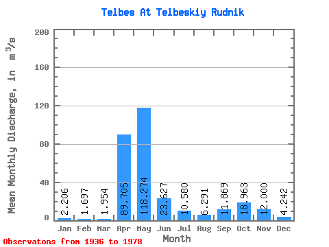
| Statistic | Jan | Feb | Mar | Apr | May | Jun | Jul | Aug | Sep | Oct | Nov | Dec | Annual |
|---|---|---|---|---|---|---|---|---|---|---|---|---|---|
| Mean | 2.21 | 1.70 | 1.95 | 89.70 | 118.27 | 23.63 | 10.58 | 6.29 | 11.87 | 18.96 | 12.00 | 4.24 | 25.12 |
| Standard Deviation | 1.13 | 0.74 | 1.06 | 37.93 | 59.48 | 19.54 | 11.77 | 4.65 | 11.22 | 14.82 | 11.15 | 2.85 | 5.43 |
| Min | 0.84 | 0.54 | 0.97 | 8.21 | 41.50 | 2.07 | 1.25 | 1.28 | 0.98 | 2.22 | 1.90 | 1.03 | 15.97 |
| Max | 6.00 | 4.28 | 6.05 | 172.00 | 262.00 | 82.90 | 50.60 | 26.80 | 51.70 | 61.20 | 54.60 | 13.00 | 37.94 |
| Coefficient of Variation | 0.51 | 0.44 | 0.55 | 0.42 | 0.50 | 0.83 | 1.11 | 0.74 | 0.94 | 0.78 | 0.93 | 0.67 | 0.22 |
 Return to R-Arctic Net Home Page