|
|
|||||||||||||||||
| Point ID: 6640 | Downloads | Plots | Site Data | Code: 9496 |
|
|
|||||||||||||||||
| Download | |
|---|---|
| Site Descriptor Information | Site Time Series Data |
| Link to all available data | |
| View: | Time Series | All |
| Units: | m3/s |
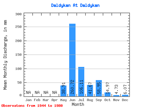
| Statistic | Jan | Feb | Mar | Apr | May | Jun | Jul | Aug | Sep | Oct | Nov | Dec | Annual |
|---|---|---|---|---|---|---|---|---|---|---|---|---|---|
| Mean | 38.90 | 260.74 | 106.08 | 41.67 | 58.95 | 14.96 | 4.72 | 6.07 | |||||
| Standard Deviation | 57.78 | 54.20 | 64.45 | 18.25 | 33.22 | 23.05 | 3.21 | ||||||
| Min | 0.72 | 173.42 | 20.15 | 11.32 | 17.90 | 0.39 | 1.60 | 6.07 | |||||
| Max | 207.06 | 358.07 | 256.48 | 72.89 | 135.75 | 77.30 | 8.02 | 6.07 | |||||
| Coefficient of Variation | 1.48 | 0.21 | 0.61 | 0.44 | 0.56 | 1.54 | 0.68 |
 Return to R-Arctic Net Home Page