|
|
|||||||||||||||||
| Point ID: 6640 | Downloads | Plots | Site Data | Code: 9496 |
|
|
|||||||||||||||||
| Download | |
|---|---|
| Site Descriptor Information | Site Time Series Data |
| Link to all available data | |
| View: | Time Series | All |
| Units: | mm |
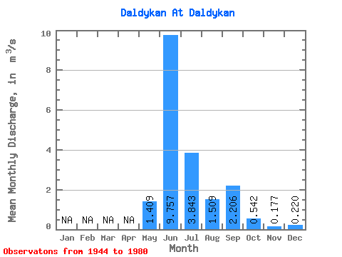
| Statistic | Jan | Feb | Mar | Apr | May | Jun | Jul | Aug | Sep | Oct | Nov | Dec | Annual |
|---|---|---|---|---|---|---|---|---|---|---|---|---|---|
| Mean | 1.41 | 9.76 | 3.84 | 1.51 | 2.21 | 0.54 | 0.18 | 0.22 | |||||
| Standard Deviation | 2.09 | 2.03 | 2.33 | 0.66 | 1.24 | 0.83 | 0.12 | ||||||
| Min | 0.03 | 6.49 | 0.73 | 0.41 | 0.67 | 0.01 | 0.06 | 0.22 | |||||
| Max | 7.50 | 13.40 | 9.29 | 2.64 | 5.08 | 2.80 | 0.30 | 0.22 | |||||
| Coefficient of Variation | 1.48 | 0.21 | 0.61 | 0.44 | 0.56 | 1.54 | 0.68 |
 Return to R-Arctic Net Home Page