|
|
|||||||||||||||||
| Point ID: 6640 | Downloads | Plots | Site Data | Code: 9496 |
|
|
|||||||||||||||||
| Download | |
|---|---|
| Site Descriptor Information | Site Time Series Data |
| Link to all available data | |
|
|
| View: | Statistics | Time Series |
| Units: | m3/s |
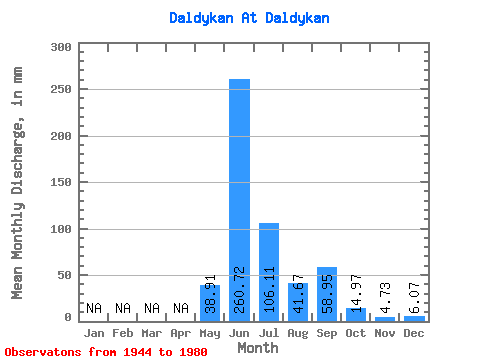
| Statistic | Jan | Feb | Mar | Apr | May | Jun | Jul | Aug | Sep | Oct | Nov | Dec | Annual |
|---|---|---|---|---|---|---|---|---|---|---|---|---|---|
| Mean | 38.90 | 260.74 | 106.08 | 41.67 | 58.95 | 14.96 | 4.72 | 6.07 | |||||
| Standard Deviation | 57.78 | 54.20 | 64.45 | 18.25 | 33.22 | 23.05 | 3.21 | ||||||
| Min | 0.72 | 173.42 | 20.15 | 11.32 | 17.90 | 0.39 | 1.60 | 6.07 | |||||
| Max | 207.06 | 358.07 | 256.48 | 72.89 | 135.75 | 77.30 | 8.02 | 6.07 | |||||
| Coefficient of Variation | 1.48 | 0.21 | 0.61 | 0.44 | 0.56 | 1.54 | 0.68 |
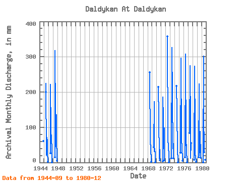
| Year | Jan | Feb | Mar | Apr | May | Jun | Jul | Aug | Sep | Oct | Nov | Dec | Annual | 1944 | 60.92 | 62.67 | 1945 | 207.06 | 225.00 | 21.26 | 72.89 | 60.66 | 29.82 | 1.60 | 1946 | 27.88 | 220.99 | 94.70 | 67.09 | 40.88 | 0.47 | 1947 | 16.01 | 317.99 | 136.94 | 46.93 | 135.75 | 77.30 | 4.54 | 1968 | 255.46 | 256.48 | 56.32 | 43.56 | 1.85 | 1969 | 44.45 | 173.42 | 31.75 | 40.58 | 22.98 | 0.64 | 1970 | 214.57 | 131.97 | 11.32 | 37.14 | 6.07 | 1971 | 3.59 | 185.45 | 130.86 | 41.14 | 97.80 | 7.18 | 1972 | 358.07 | 72.06 | 43.07 | 22.18 | 0.39 | 1973 | 12.15 | 326.00 | 191.88 | 41.41 | 95.13 | 12.15 | 1974 | 217.78 | 149.64 | 33.13 | 42.22 | 1.10 | 1975 | 29.27 | 296.61 | 67.09 | 43.07 | 45.69 | 5.80 | 1976 | 15.46 | 307.30 | 50.25 | 69.30 | 35.81 | 1.02 | 1977 | 86.14 | 275.23 | 103.53 | 12.70 | 55.05 | 1978 | 8.56 | 272.56 | 89.45 | 22.64 | 17.90 | 2.07 | 1979 | 15.46 | 223.39 | 20.15 | 34.23 | 88.18 | 14.08 | 1980 | 0.72 | 301.95 | 149.36 | 30.92 | 100.21 | 16.84 | 8.02 | 6.07 |
|---|
 Return to R-Arctic Net Home Page