|
|
|||||||||||||||||
| Point ID: 6636 | Downloads | Plots | Site Data | Code: 9445 |
|
|
|||||||||||||||||
| Download | |
|---|---|
| Site Descriptor Information | Site Time Series Data |
| Link to all available data | |
| View: | Time Series | All |
| Units: | m3/s |
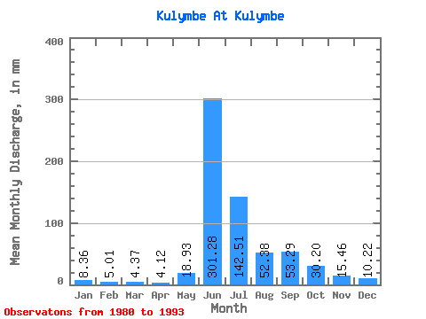
| Statistic | Jan | Feb | Mar | Apr | May | Jun | Jul | Aug | Sep | Oct | Nov | Dec | Annual |
|---|---|---|---|---|---|---|---|---|---|---|---|---|---|
| Mean | 8.35 | 5.05 | 4.36 | 4.12 | 18.92 | 301.28 | 142.49 | 52.37 | 53.29 | 30.20 | 15.46 | 10.22 | 642.18 |
| Standard Deviation | 3.77 | 1.87 | 1.64 | 1.43 | 13.45 | 106.65 | 108.89 | 19.75 | 22.67 | 17.04 | 4.04 | 3.25 | 143.06 |
| Min | 5.15 | 2.50 | 2.71 | 2.61 | 4.24 | 107.45 | 43.73 | 29.75 | 24.53 | 14.24 | 7.95 | 5.52 | 481.87 |
| Max | 15.68 | 8.49 | 7.70 | 6.73 | 44.07 | 450.32 | 380.51 | 100.00 | 90.23 | 75.34 | 21.00 | 16.53 | 857.32 |
| Coefficient of Variation | 0.45 | 0.37 | 0.38 | 0.35 | 0.71 | 0.35 | 0.76 | 0.38 | 0.42 | 0.56 | 0.26 | 0.32 | 0.22 |
 Return to R-Arctic Net Home Page